ZCZC MIATWOAT ALL
TTAA00 KNHC DDHHMM
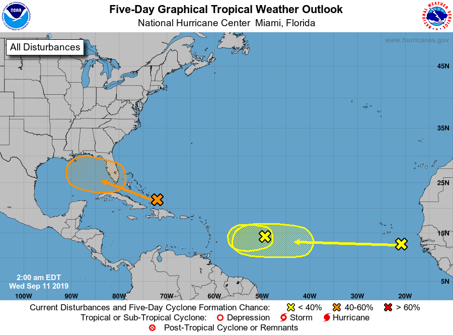
Tropical Weather Outlook
NWS National Hurricane Center Miami FL
200 AM EDT Wed Sep 11 2019
For the North Atlantic...Caribbean Sea and the Gulf of Mexico:
1. A surface trough located over the Turks and Caicos continues to
produce widespread cloudiness and disorganized thunderstorms across
the southeastern Bahamas and the Turks and Caicos, and extending
northward over the southwestern Atlantic for a few hundred miles.
Ship reports continue to indicate that tropical-storm-force wind
gusts are occurring in some of the heavier squalls. Limited
development of this disturbance is expected during the next few days
due to only marginally conducive upper-level winds while the system
moves very slowly west-northwestward across the Bahamas. However,
environmental conditions could become more favorable for development
when the system moves over the Florida Straits and into the eastern
Gulf of Mexico by Friday and over the weekend. Regardless of
development, this disturbance will produce periods of locally heavy
rainfall and gusty winds across the Bahamas through Thursday, and
across Florida by late Friday and continuing into the weekend.
* Formation chance through 48 hours...low...10 percent.
* Formation chance through 5 days...medium...50 percent.
2. A broad low pressure system, associated with a tropical wave, is
located about 800 miles east of the Lesser Antilles. Although this
disturbance continues to produce disorganized shower activity,
some slight development of this system is still possible on
Wednesday. By Thursday, however, upper-level winds are forecast to
become unfavorable for tropical cyclone formation. This disturbance
is expected to move slowly westward across the tropical Atlantic
Ocean for the next several days.
* Formation chance through 48 hours...low...20 percent.
* Formation chance through 5 days...low...20 percent.
3. A tropical wave located between the west coast of Africa and the
Cabo Verde Islands is forecast to move quickly westward during the
next several days. Some slow development is possible over the
weekend or early next week when the system is expected to be a
couple of hundred miles east of the Lesser Antilles.
* Formation chance through 48 hours...low...near 0 percent.
* Formation chance through 5 days...low...20 percent.
Forecaster Stewart