ZCZC MIATWOAT ALL
TTAA00 KNHC DDHHMM
Tropical Weather Outlook
NWS National Hurricane Center Miami FL
800 PM EDT Mon Sep 9 2019
For the North Atlantic...Caribbean Sea and the Gulf of Mexico:
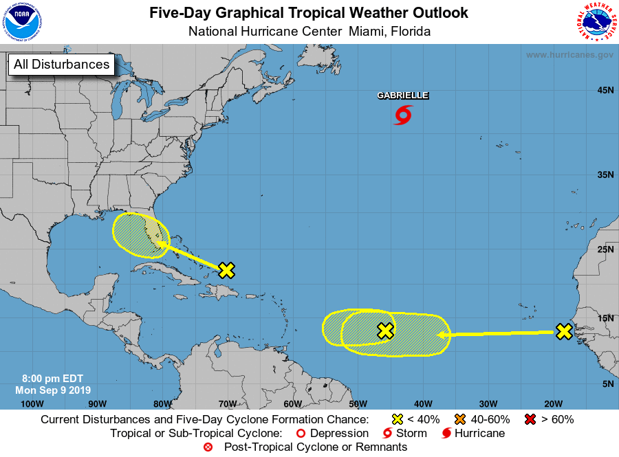
The National Hurricane Center is issuing advisories on Tropical
Storm Gabrielle, located over the far north Atlantic Ocean.
1. A weak area of low pressure, associated with a tropical wave,
located more than 900 miles east of the Lesser Antilles continues
to produce disorganized showers and thunderstorms. Some slow
development of this system is possible during the next few days
before upper-level winds become unfavorable for tropical cyclone
formation. This system is expected to move generally westward
across the tropical Atlantic Ocean for the next several days.
* Formation chance through 48 hours...low...20 percent.
* Formation chance through 5 days...low...30 percent.
2. A surface trough interacting with an upper-level low is producing
disorganized showers and thunderstorms from the north coast of
Hispaniola northward over the southwestern Atlantic for a few
hundred miles. Little, if any, development of this disturbance is
expected during the next few days while it moves west-northwestward
across the Bahamas and the Florida peninsula. However, environmental
conditions could become a little more conducive for development
when the system moves into the Gulf of Mexico over the weekend.
Regardless of development, this disturbance will produce periods of
gusty winds and locally heavy rainfall across the Bahamas through
Thursday, and across Florida on Friday and continuing into the
weekend.
* Formation chance through 48 hours...low...near 0 percent.
* Formation chance through 5 days...low...20 percent.
3. A tropical wave located just off the west coast of Africa is
expected to move quickly westward during the next several days.
Some slow development is possible late this week and over the
weekend when the system is several hundred miles east of the
Lesser Antilles.
* Formation chance through 48 hours...low...near 0 percent.
* Formation chance through 5 days...low...20 percent.
Forecaster Stewart