ZCZC MIATWOAT ALL
TTAA00 KNHC DDHHMM
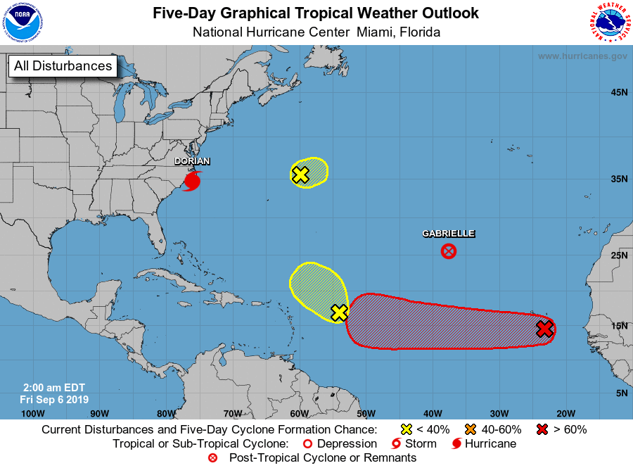
Tropical Weather Outlook
NWS National Hurricane Center Miami FL
200 AM EDT Fri Sep 6 2019
For the North Atlantic...Caribbean Sea and the Gulf of Mexico:
The National Hurricane Center is issuing advisories on Hurricane
Dorian, located just to the southwest of Cape Lookout, North
Carolina, and on Tropical Storm Gabrielle, located about 1000 miles
northwest of the Cabo Verde Islands.
1. A small low pressure system is located about 400 miles northeast of
Bermuda. Shower activity has diminished, and further development of
this system not anticipated due to unfavorable upper level winds
caused by Hurricane Dorian.
* Formation chance through 48 hours...low...near 0 percent.
* Formation chance through 5 days...low...near 0 percent.
2. Disorganized showers and thunderstorms located several hundred miles
east of the Leeward Islands are associated with a tropical wave.
Development, if any, of this system will be slow to occur while it
moves slowly northwestward.
* Formation chance through 48 hours...low...10 percent.
* Formation chance through 5 days...low...10 percent.
3. A low pressure system located near the southern Cabo Verde Islands
is producing a small area of disorganized showers and thunderstorms,
mainly to the west of the center. Little if any development of this
disturbance is expected for the next couple of days, but
environmental conditions are expected to become for a tropical
depression form early next week while the system moves westward
across the tropical Atlantic Ocean. Enhanced rainfall is possible
across the Cabo Verde Islands through today while the low moves
across the area.
* Formation chance through 48 hours...low...20 percent.
* Formation chance through 5 days...high...70 percent.
Forecaster Stewart