ZCZC MIATWOAT ALL
TTAA00 KNHC DDHHMM
Tropical Weather Outlook
NWS National Hurricane Center Miami FL
800 PM EDT Thu Sep 5 2019
For the North Atlantic...Caribbean Sea and the Gulf of Mexico:
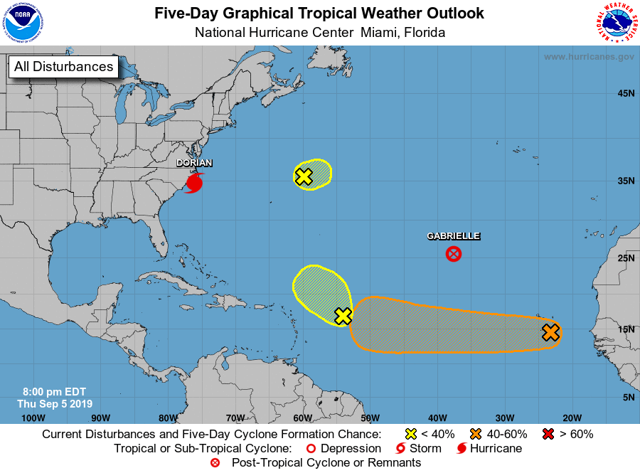
The National Hurricane Center is issuing advisories on Hurricane
Dorian, located near Myrtle Beach, South Carolina, and on Tropical
Storm Gabrielle, located nearly 1000 miles northwest of the Cabo
Verde Islands.
1. A small area of low pressure located several hundred miles northeast
of Bermuda is producing limited showers and thunderstorms, well to
the southeast of the center. Development of this system is expected
to be limited due to unfavorable upper level winds.
* Formation chance through 48 hours...low...10 percent.
* Formation chance through 5 days...low...10 percent.
2. Disorganized showers and thunderstorms located several hundred miles
east of the Leeward Islands are associated with a tropical wave.
Development, if any, will be slow to occur while it moves slowly
northwestward.
* Formation chance through 48 hours...low...10 percent.
* Formation chance through 5 days...low...10 percent.
3. A broad area of low pressure along a tropical wave located near the
Cabo Verde Islands is producing disorganized showers and
thunderstorms. Gradual development of this system is possible, and a
tropical depression could form while it moves westward across the
tropical Atlantic Ocean through early next week. Enhanced rainfall
is possible across the Cabo Verde Islands through early Friday as
the disturbance moves through the region.
* Formation chance through 48 hours...low...20 percent.
* Formation chance through 5 days...medium...60 percent.
Forecaster Latto