ZCZC MIATWOAT ALL
TTAA00 KNHC DDHHMM
Tropical Weather Outlook
NWS National Hurricane Center Miami FL
200 PM EDT Thu Sep 5 2019
For the North Atlantic...Caribbean Sea and the Gulf of Mexico:
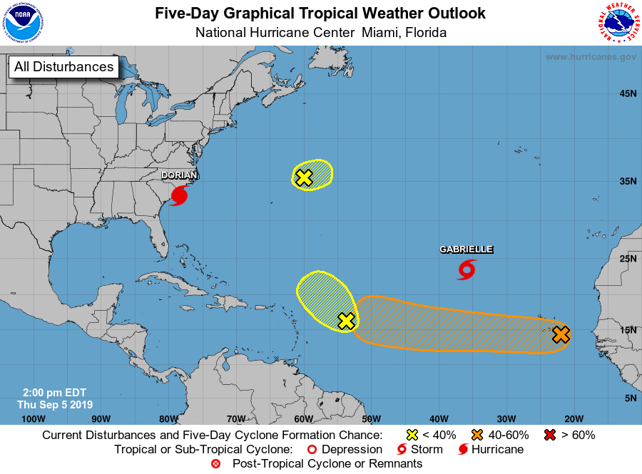
The National Hurricane Center is issuing advisories on Hurricane
Dorian, located just east of Charleston, South Carolina, and on
Tropical Storm Gabrielle, located nearly 1000 miles northwest of
the Cabo Verde Islands.
1. A small area of low pressure located a few hundred miles northeast
of Bermuda is producing limited showers and thunderstorms, well to
the southeast of the center. This system has become poorly defined
and significant development is not anticipated.
* Formation chance through 48 hours...low...10 percent.
* Formation chance through 5 days...low...10 percent.
2. An area of disturbed weather located several hundred miles east of
the Leeward Islands is associated with a tropical wave. Only slow
development of this disturbance, if any, is expected during the next
couple of days while it moves slowly northwestward.
* Formation chance through 48 hours...low...10 percent.
* Formation chance through 5 days...low...10 percent.
3. A broad area of low pressure associated with a tropical wave located
about 100 miles east of the Cabo Verde Islands continues to produce
disorganized showers and thunderstorms. Gradual development of this
system is possible and a tropical depression could form while it
moves westward across the tropical Atlantic Ocean through early next
week. Enhanced rainfall is possible across the Cabo Verde Islands
through early Friday as the disturbance moves through the region.
* Formation chance through 48 hours...low...20 percent.
* Formation chance through 5 days...medium...60 percent.
Forecaster Zelinsky