ABNT20 KNHC 031800
TWOAT
Tropical Weather Outlook
NWS National Hurricane Center Miami FL
Issued by the NWS Weather Prediction Center College Park MD
200 PM EDT Tue Sep 3 2019
For the North Atlantic...Caribbean Sea and the Gulf of Mexico:
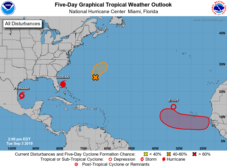
The National Hurricane Center is issuing advisories on Hurricane
Dorian, located north of Grand Bahama Island.
The National Hurricane Center is issuing advisories on newly
formed Tropical Storm Fernand, located over the southwestern Gulf of
Mexico.
1. An area of low pressure located a few hundred miles west of the Cabo
Verde Islands continues to exhibit a broad circulation. Any
significant increase in thunderstorms would contribute to the
formation of a tropical depression.
* Formation chance through 48 hours...high...90 percent.
* Formation chance through 5 days...high...90 percent.
2. Showers and thunderstorms associated with a trough of low pressure,
located several hundred miles south of Bermuda were showing some
signs of organization. Development of this disturbance is possible
during the next couple of days while it moves northward. Interests
in Bermuda should monitor the progress of this system. Periods of
heavy rainfall are likely to impact Bermuda.
* Formation chance through 48 hours...medium...50 percent.
* Formation chance through 5 days...medium...50 percent.
3. tropical wave is forecast to emerge over the far eastern tropical
Atlantic between Africa and the Cabo Verde Islands by Thursday.
Environmental conditions are forecast to be conducive for
development and a tropical depression is likely to form by late this
week while the system moves westward to west-northwestward.
* Formation chance through 48 hours...low...near 0 percent.
* Formation chance through 5 days...high...70 percent.
Forecaster Carbin
&&