ZCZC MIATWOAT ALL
TTAA00 KNHC DDHHMM
Tropical Weather Outlook
NWS National Hurricane Center Miami FL
800 AM EDT Tue Sep 3 2019
For the North Atlantic...Caribbean Sea and the Gulf of Mexico:
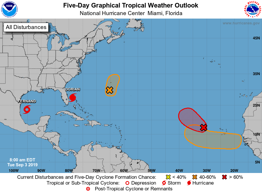
The National Hurricane Center is issuing advisories on Hurricane
Dorian, located just north of Grand Bahama Island.
The National Hurricane Center is issuing advisories on newly
formed Potential Tropical Cyclone Seven, located over the
southwestern Gulf of Mexico.
* Formation chance through 48 hours...high...near 100 percent.
* Formation chance through 5 days...high...near 100 percent.
1. An area of low pressure located a few hundred miles west of the
Cabo Verde Islands continues to become better defined. The
associated thunderstorm activity has been increasing, and a tropical
depression is expected to form later today while the system moves
generally northwestward across the eastern tropical Atlantic Ocean.
* Formation chance through 48 hours...high...90 percent.
* Formation chance through 5 days...high...90 percent.
2. A trough of low pressure, located several hundred miles south of
Bermuda, is producing disorganized showers and thunderstorms. Some
development of the disturbance is possible during the next couple of
days while the system moves northward, and a tropical depression
could form by Thursday. Afterward, upper-level winds are forecast
to become less favorable for tropical cyclone formation. Interests
in Bermuda should monitor the progress of this system, and areas of
heavy rainfall are likely.
* Formation chance through 48 hours...medium...40 percent.
* Formation chance through 5 days...medium...40 percent.
3. A tropical wave is forecast to emerge over the far eastern tropical
Atlantic between Africa and the Cabo Verde Islands in a couple of
days. Environmental conditions are forecast to be conducive for
development, and a tropical depression is likely to form late this
week or over the weekend while the system moves westward to
west-northwestward.
* Formation chance through 48 hours...low...near 0 percent.
* Formation chance through 5 days...medium...60 percent.
Forecaster Blake