ZCZC MIATWOAT ALL
TTAA00 KNHC DDHHMM
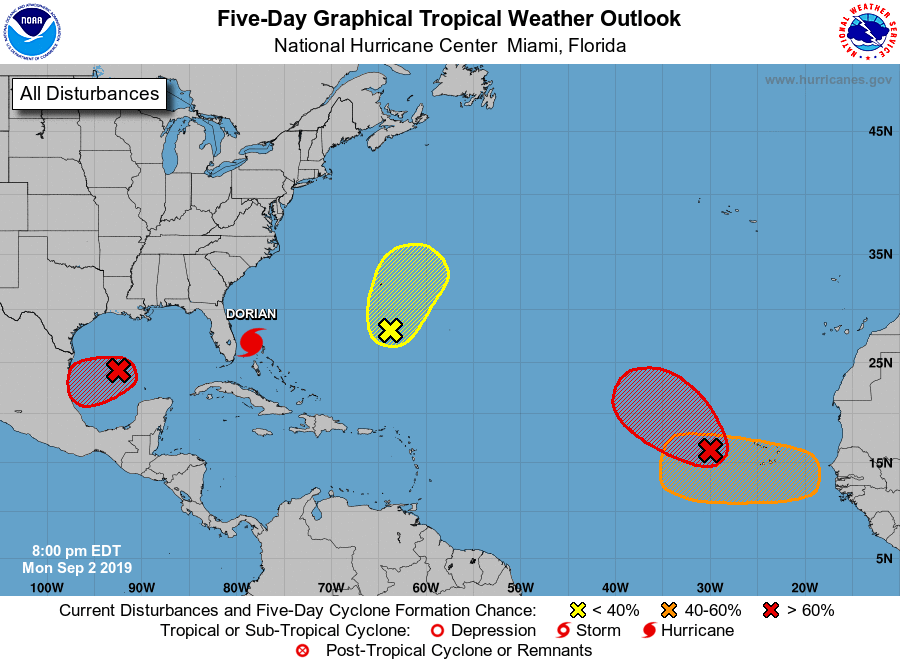
Tropical Weather Outlook
NWS National Hurricane Center Miami FL
800 PM EDT Mon Sep 2 2019
For the North Atlantic...Caribbean Sea and the Gulf of Mexico:
The National Hurricane Center is issuing advisories on Hurricane
Dorian, located near Grand Bahama Island.
1. An elongated area of low pressure is located a few hundred miles
west of the Cabo Verde Islands. Although this system is currently
producing limited showers and thunderstorms, a tropical depression
is expected to form during the next day or so while the system moves
generally northwestward across the eastern tropical Atlantic Ocean.
* Formation chance through 48 hours...high...80 percent.
* Formation chance through 5 days...high...90 percent.
2. An extensive area of showers and thunderstorms continues in
association with an area of low pressure located over the
south-central Gulf of Mexico. Environmental conditions appear
conducive for additional development, and a tropical depression is
likely to form during the next few days while the low moves
slowly westward or west-southwestward toward the coast of Mexico.
Interests along the northeast coast of Mexico should monitor the
progress of this system.
* Formation chance through 48 hours...medium...60 percent.
* Formation chance through 5 days...high...70 percent.
3. A trough of low pressure, located several hundred miles
south-southeast of Bermuda, is producing disorganized showers and
thunderstorms. Some gradual development of the disturbance is
possible during the next couple of days. Afterward, upper-level
winds are forecast to become less favorable for tropical cyclone
formation. Interests in Bermuda should monitor the progress of this
disturbance.
* Formation chance through 48 hours...low...30 percent.
* Formation chance through 5 days...medium...30 percent.
4. A tropical wave is forecast to emerge over the far eastern tropical
Atlantic between Africa and the Cabo Verde Islands in a few days.
Environmental conditions are forecast to be conducive for
development, and a tropical depression could form late this week or
over the weekend while the system moves westward to
west-northwestward.
* Formation chance through 48 hours...low...near 0 percent.
* Formation chance through 5 days...medium...50 percent.
High Seas Forecasts issued by the National Weather Service
can be found under AWIPS header NFDHSFAT1, WMO header FZNT01
KWBC, and online at ocean.weather.gov/shtml/NFDHSFAT1.php
Forecaster Roberts