ZCZC MIATWOAT ALL
TTAA00 KNHC DDHHMM
Tropical Weather Outlook
NWS National Hurricane Center Miami FL
800 PM EDT Sat Aug 24 2019
For the North Atlantic...Caribbean Sea and the Gulf of Mexico:
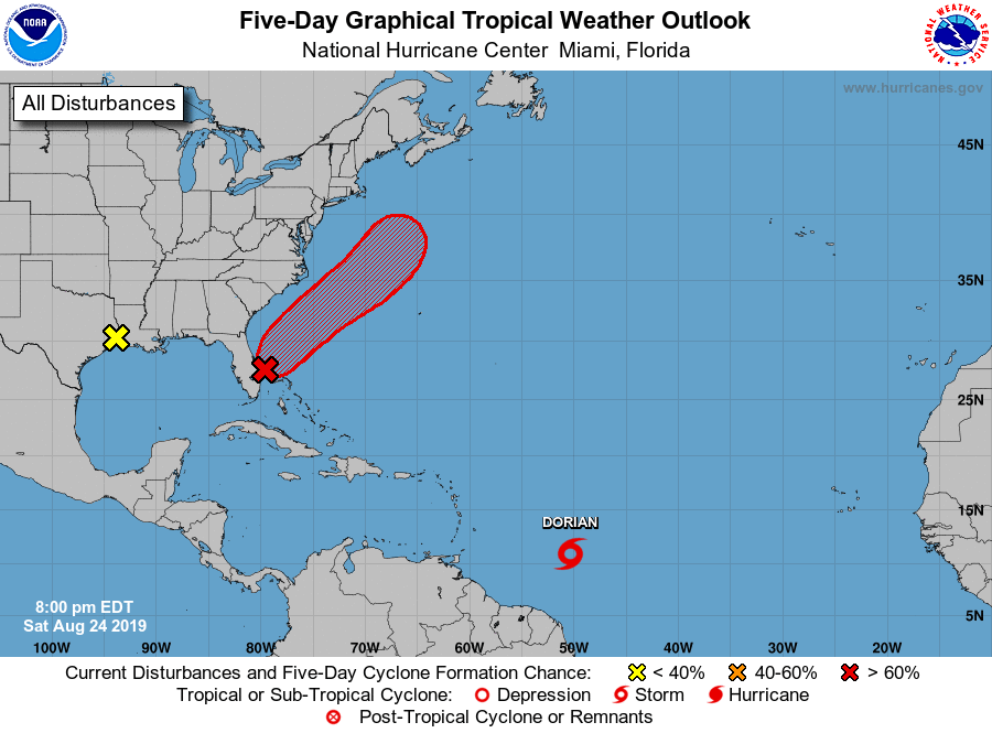
The National Hurricane Center is issuing advisories on Tropical
Storm Dorian, located several hundred miles east-southeast of
the Lesser Antilles.
1. A trough of low pressure extending from the coast of south-central
Florida northeastward over the western Atlantic for a few hundred
miles continues to produce a large area of disorganized showers and
thunderstorms. Environmental conditions appear conducive for
gradual development during the next few days, and a tropical or
subtropical depression is likely to form early next week while the
system moves northeastward over the Atlantic, offshore of the
southeastern United States coast. Interests along the coasts of
South and North Carolina should continue to monitor the progress
of this system. An Air Force Reserve Hurricane Hunter aircraft is
scheduled to investigate the system on Sunday, if necessary.
* Formation chance through 48 hours...high...70 percent.
* Formation chance through 5 days...high...90 percent.
2. Satellite and surface observations show that the trough of low
pressure over the far northwestern Gulf of Mexico has moved inland
over the Upper Texas coast and western Louisiana. Although further
development of this system is not expected, it will likely bring
locally heavy rains to portions of Louisiana and eastern Texas
during the next day or two. See products issued by your local
National Weather Service office for additional information.
* Formation chance through 48 hours...low...near 0 percent.
* Formation chance through 5 days...low...near 0 percent.
Public Advisories on Dorian are issued under WMO header WTNT35 KNHC
and under AWIPS header MIATCPAT5. Forecast/Advisories on Dorian
are issued under WMO header WTNT25 KNHC and under AWIPS header
MIATCMAT5.
Forecaster Brown