ZCZC MIATWOAT ALL
TTAA00 KNHC DDHHMM
Tropical Weather Outlook
NWS National Hurricane Center Miami FL
200 PM EDT Sat Aug 24 2019
For the North Atlantic...Caribbean Sea and the Gulf of Mexico:
The National Hurricane Center is issuing advisories on newly-formed
Tropical Depression Five, located about 800 miles east-southeast of
Barbados.
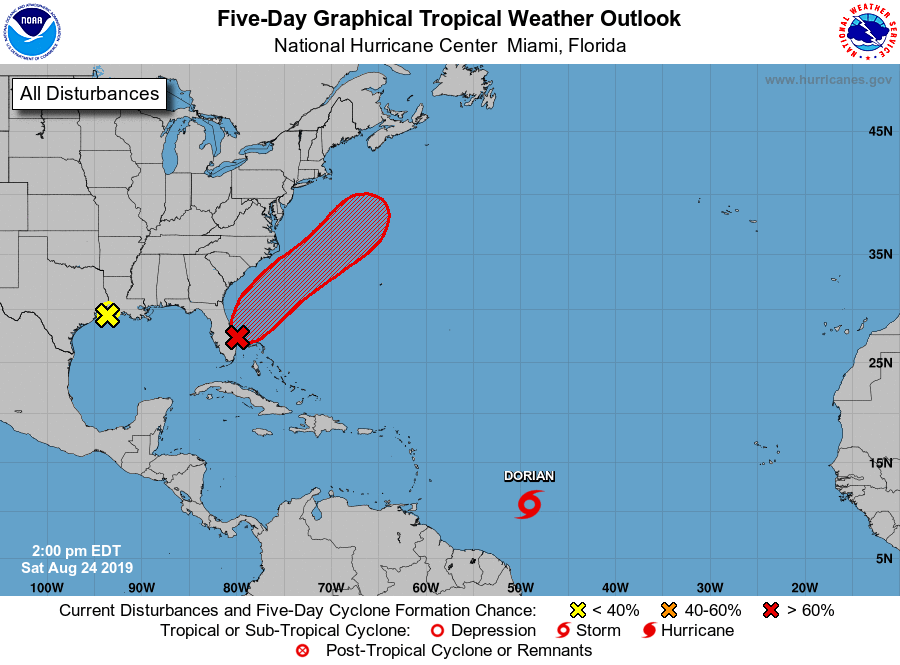
1. A broad and elongated area of low pressure extending from the
southern Florida peninsula northeastward into the Atlantic is
producing a large area of disorganized showers and thunderstorms,
primarily over the Atlantic north of the Bahamas and east of the
central Florida peninsula. Environmental conditions appear
conducive for gradual development during the next few days, and a
tropical or subtropical depression is likely to form early next week
while the system moves northeastward over the Atlantic offshore of
the southeastern United States coast.
Regardless of development, locally heavy rains are possible over the
northwestern Bahamas and the southern and central Florida peninsula
through the weekend. Interests in the northwestern Bahamas, the
Florida peninsula, and the southeastern coast of the United States
should monitor the progress of this system. An Air Force Reserve
Hurricane Hunter aircraft is scheduled to investigate the system on
Sunday, if necessary.
* Formation chance through 48 hours...high...70 percent.
* Formation chance through 5 days...high...90 percent.
2. Surface observations along with satellite imagery and radar data
indicate that a low pressure area is located near the upper
Texas and southwestern Louisiana coasts. The associated shower and
thunderstorm activity shows signs of organization. However, the
system is likely to move inland over eastern Texas and western
Louisiana before tropical cyclone formation can occur. Regardless
of development, this system is expected to bring locally heavy rains
to portions of Louisiana and eastern Texas during the next day or
two.
* Formation chance through 48 hours...low...10 percent.
* Formation chance through 5 days...low...10 percent.
Public Advisories on Tropical Depression Five are issued under WMO
header WTNT35 KNHC and under AWIPS header MIATCPAT5.
Forecast/Advisories on Tropical Depression Five are issued under WMO
header WTNT25 KNHC and under AWIPS header MIATCMAT5.
Forecaster Beven