ZCZC MIATWOAT ALL
TTAA00 KNHC DDHHMM
Tropical Weather Outlook
NWS National Hurricane Center Miami FL
800 PM EDT Fri Sep 21 2018
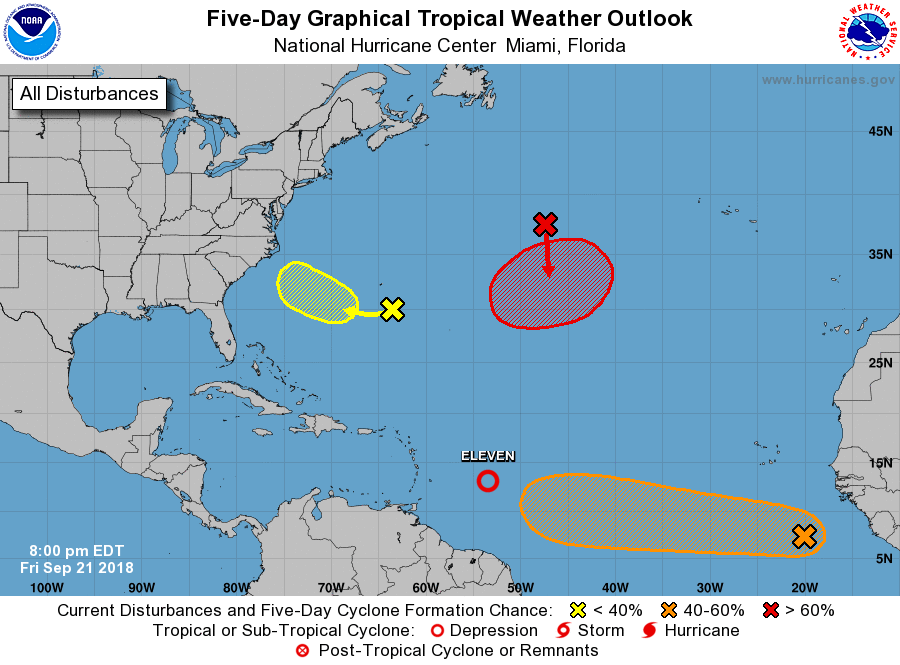
For the North Atlantic...Caribbean Sea and the Gulf of Mexico:
1. A low pressure system is located about 600 miles south-southeast of
the Cabo Verde Islands. Although the low is currently producing
only limited shower and thunderstorm activity, the system appears
to have become better organized since earlier today and a tropical
depression could form during the next day or two. This system is
expected to move westward at 15 to 20 mph across the low latitudes
of the eastern and central tropical Atlantic Ocean through early
next week.
* Formation chance through 48 hours...medium...40 percent.
* Formation chance through 5 days...medium...60 percent.
2. A well-defined low pressure system located about 400 miles east of
the Windward Islands has produced persistent thunderstorms just east
of its center for the past several hours. If current trends
continue, advisories could be issued on a tropical depression later
tonight or on Saturday. By late this weekend, strong upper-level
winds and dry air are likely to prevent further development of this
system while it moves west-northwestward to northwestward at
around 10 mph.
* Formation chance through 48 hours...medium...60 percent.
* Formation chance through 5 days...medium...60 percent.
3. A broad area of low pressure is located a little more than 150 miles
southeast of Bermuda. This low is producing minimal shower
activity, and little development is anticipated for the next day or
two. However, environmental conditions could become more conducive
for slow development by late this weekend or early next week when
the system moves over the southwestern Atlantic Ocean.
* Formation chance through 48 hours...low...10 percent.
* Formation chance through 5 days...low...30 percent.
4. A non-tropical low pressure system is expected to develop early this
weekend over the north-central Atlantic Ocean, midway between
Bermuda and the Azores. Conditions are expected to be conducive for
the low to acquire subtropical or tropical characteristics, and a
subtropical or tropical cyclone is likely to form late this weekend
or early next week while the low meanders over the central Atlantic
Ocean.
* Formation chance through 48 hours...low...30 percent.
* Formation chance through 5 days...high...70 percent.
Forecaster Zelinsky