ZCZC MIATWOAT ALL
TTAA00 KNHC DDHHMM
Tropical Weather Outlook
NWS National Hurricane Center Miami FL
800 PM EDT Wed Sep 12 2018
For the North Atlantic...Caribbean Sea and the Gulf of Mexico:
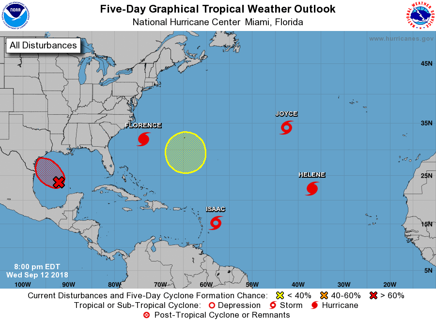
The National Hurricane Center is issuing advisories on Hurricane
Florence, located over the western Atlantic Ocean, on Hurricane
Helene, located over the eastern Atlantic Ocean, on Tropical
Storm Isaac, located a few hundred miles east of the Lesser
Antilles, and on newly formed Subtropical Storm Joyce, located
several hundred miles west-southwest of the Azores.
1. A broad area of low pressure is located over the central Gulf of
Mexico. Although the shower activity is still disorganized,
upper-level winds are forecast to become more conducive for
development, and it is likely that a tropical depression will form
Thursday or Thursday night, before the system reaches the western
Gulf coast. An Air Force Reserve Hurricane Hunter aircraft is
scheduled to investigate the disturbance tomorrow, if necessary.
Regardless of development, heavy rainfall and gusty winds are
expected across portions of northeastern Mexico, Texas, and
Louisiana late this week. Interests there should monitor the
progress of this system, and refer to products from their local
weather office.
* Formation chance through 48 hours...high...70 percent.
* Formation chance through 5 days...high...70 percent.
2. An area of low pressure is expected to develop near Bermuda late
this weekend or early next week. Some gradual development is
possible after that time while the system drifts westward over the
western Atlantic.
* Formation chance through 48 hours...low...near 0 percent.
* Formation chance through 5 days...low...20 percent.
Public Advisories on Subtropical Storm Joyce are issued under WMO
header WTNT35 KNHC and under AWIPS header MIATCPAT5.
Forecast/Advisories on Subtropical Storm Joyce are issued under WMO
header WTNT25 KNHC and under AWIPS header MIATCMAT5.
Forecaster Beven