ZCZC MIATWOAT ALL
TTAA00 KNHC DDHHMM
Tropical Weather Outlook
NWS National Hurricane Center Miami FL
200 PM EDT Wed Sep 12 2018
For the North Atlantic...Caribbean Sea and the Gulf of Mexico:
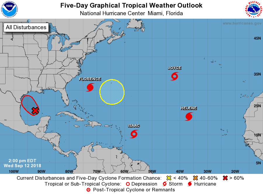
The National Hurricane Center is issuing advisories on Hurricane
Florence, located over the western Atlantic Ocean, on Hurricane
Helene, located over the eastern Atlantic Ocean, and on Tropical
Storm Isaac, located a few hundred miles east of the Lesser
Antilles.
1. Satellite images and surface observations indicate that a broad
area of low pressure has formed in the central Gulf of Mexico.
Although the shower activity is still disorganized, upper-level
winds are forecast to become more conducive for development, and
it is likely that a tropical depression will form on Thursday,
before the system reaches the western Gulf coast. Another
reconnaissance plane is scheduled to investigate the disturbance
tomorrow. Regardless of development, heavy rainfall and gusty winds
are expected across portions of northeastern Mexico, Texas, and
Louisiana late this week, and interests there should monitor the
progress of this system, and refer to products from their local
weather office.
* Formation chance through 48 hours...high...70 percent.
* Formation chance through 5 days...high...70 percent.
2. Satellite images indicate that a strong area of low pressure located
a little more than 600 miles west-southwest of the Azores is rapidly
becoming better organized and a subtropical or tropical storm
appears to be forming. If this trend continues, advisories will be
initiated later today or tonight. The low is forecast to move toward
the southwest for the next couple of days, and then turn to the
northeast behind Hurricane Helene. For more information, see High
Seas Forecasts issued by the National Weather Service.
* Formation chance through 48 hours...high...90 percent.
* Formation chance through 5 days...high...90 percent.
3. An area of low pressure is expected to develop near Bermuda late
this weekend or early next week. Some gradual development is
possible after that time while the system drifts westward over the
western Atlantic.
* Formation chance through 48 hours...low...near 0 percent.
* Formation chance through 5 days...low...20 percent.
High Seas Forecasts issued by the National Weather Service are under
AWIPS header NFDHSFAT1, WMO header FZNT01 KWBC, and available on the
Web at https://ocean.weather.gov/shtml/NFDHSFAT1.shtml.
Forecaster Avila