ZCZC MIATWOAT ALL
TTAA00 KNHC DDHHMM
Tropical Weather Outlook
NWS National Hurricane Center Miami FL
200 AM EDT Wed Sep 12 2018
For the North Atlantic...Caribbean Sea and the Gulf of Mexico:
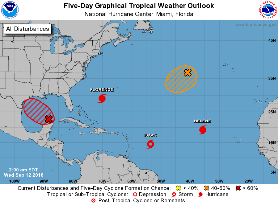
The National Hurricane Center is issuing advisories on Hurricane
Florence, located over the western Atlantic Ocean, on Hurricane
Helene, located over the eastern Atlantic, and on Tropical Storm
Isaac, located several hundred miles east of the Lesser Antilles.
1. Showers and thunderstorms have not become any better organized
during the past several hours in association with a trough of low
pressure located over the south-central Gulf of Mexico. In
addition, satellite data and surface observations indicate that
there is still no sign of a surface circulation. However,
upper-level winds are forecast to become more conducive for
development, and a tropical depression is likely to form on Thursday
or Friday before the system reaches the western Gulf Coast. An Air
Force reconnaissance plane is scheduled to investigate the system
later today, if necessary. Regardless of development, heavy rainfall
and gusty winds are expected across portions of northeastern Mexico,
Texas, and Louisiana late this week, and interests there should
monitor the progress of this system.
* Formation chance through 48 hours...medium...50 percent.
* Formation chance through 5 days...high...70 percent.
2. A non-tropical area of low pressure located several hundred
miles west of the Azores is producing a large area of showers and
thunderstorms and gale-force winds. This system could gradually
acquire tropical or subtropical characteristics during the next few
days while it meanders over the northeastern Atlantic Ocean. For
more information, see High Seas Forecasts issued by the National
Weather Service.
* Formation chance through 48 hours...medium...40 percent.
* Formation chance through 5 days...medium...50 percent.
High Seas Forecasts issued by the National Weather Service are under
AWIPS header NFDHSFAT1, WMO header FZNT01 KWBC, and available on the
Web at https://ocean.weather.gov/shtml/NFDHSFAT1.shtml.
Forecaster Cangialosi