ZCZC MIATWOAT ALL
TTAA00 KNHC DDHHMM
Special Tropical Weather Outlook
NWS National Hurricane Center Miami FL
455 PM EDT Wed Jul 4 2018
For the North Atlantic...Caribbean Sea and the Gulf of Mexico:
Special tropical weather outlook issued to update the discussion of
the low pressure area west-southwest of the Cabo Verde Islands.
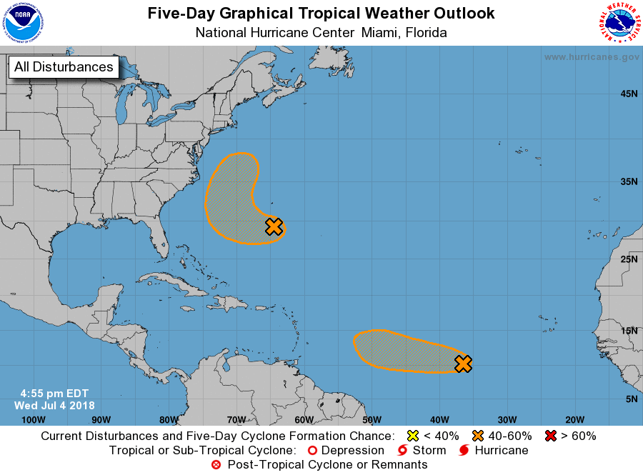
1. Disorganized showers and thunderstorms located within a few hundred
miles to the south of Bermuda are associated with a trough of low
pressure. Environmental conditions appear conducive for some
development of this system, and a tropical depression could form
before the end of the week while the system moves west-northwestward
and then northward between Bermuda and the east coast of the United
States. The system is then forecast to interact with a frontal
system on Sunday, which would limit any additional development.
* Formation chance through 48 hours...medium...40 percent.
* Formation chance through 5 days...medium...60 percent.
2. Satellite imagery indicates that shower activity associated with a
small area of low pressure and a tropical wave located several
hundred miles west-southwest of the Cabo Verde Islands has become
better organized during the past few hours. Some additional
development of this system is possible, and a tropical depression
could form during the next day or two while it moves westward to
west-northwestward at 15 to 20 mph over the tropical Atlantic
Ocean. By the weekend, upper-level winds are expected to become less
conducive for development when the system approaches the Lesser
Antilles.
* Formation chance through 48 hours...medium...50 percent.
* Formation chance through 5 days...medium...50 percent.
Forecaster Beven