ZCZC MIATWOAT ALL
TTAA00 KNHC DDHHMM
Tropical Weather Outlook
NWS National Hurricane Center Miami FL
800 AM EDT Thu Oct 5 2017
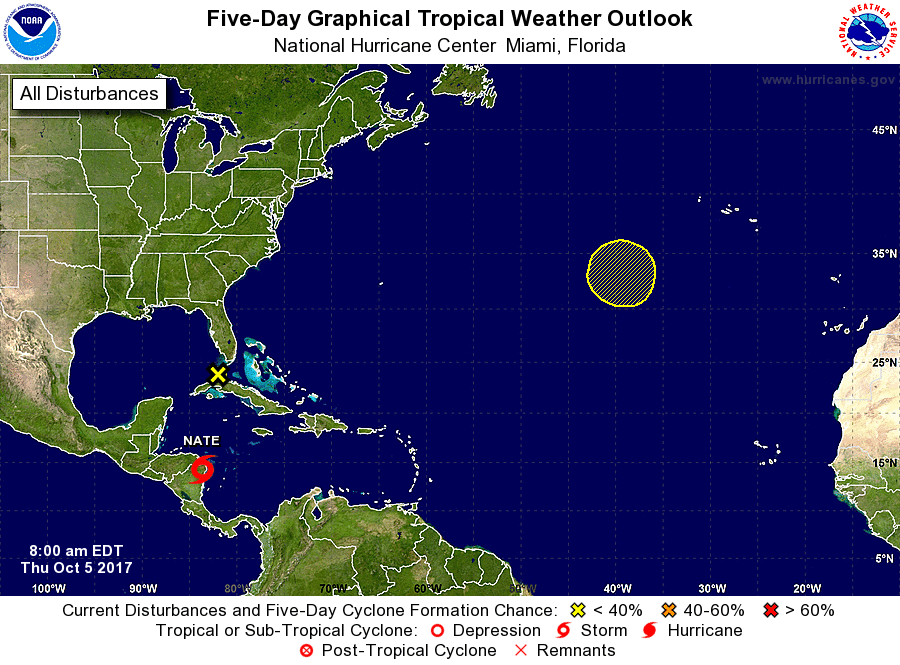
For the North Atlantic...Caribbean Sea and the Gulf of Mexico:
The National Hurricane Center is issuing advisories on recently
upgraded Tropical Storm Nate, located over northeastern Nicaragua.
1. A non-tropical area of low pressure is in the Florida Straits
centered about 50 miles southwest of Key West. This low is
interacting with an upper-level low to produce a broad area of
disorganized showers and thunderstorms across southern Florida, the
northwestern Bahamas, central Cuba, and the adjacent Atlantic
waters. Upper-level winds are forecast to be unfavorable for
tropical cyclone formation while the system moves west-northwestward
over the eastern Gulf of Mexico during the next day or two.
However, locally heavy rainfall, some coastal flooding, and strong
gusty winds, especially in squalls, are likely over portions of the
Bahamas and Florida during the next couple of days.
* Formation chance through 48 hours...low...near 0 percent.
* Formation chance through 5 days...low...near 0 percent.
2. An area of low pressure is forecast to form on a frontal boundary in
a few days about 900 miles southwest of the Azores. This low
could acquire some subtropical or tropical characteristics early
next week while it remains nearly stationary over the northeastern
Atlantic Ocean.
* Formation chance through 48 hours...low...near 0 percent.
* Formation chance through 5 days...low...20 percent.
Public Advisories on Nate are issued under WMO header WTNT31 KNHC
and under AWIPS header MIATCPAT1.
Forecast/Advisories on Nate are issued under WMO header WTNT21 KNHC
and under AWIPS header MIATCMAT1.
Forecaster Blake