ZCZC MIATWOAT ALL
TTAA00 KNHC DDHHMM
Tropical Weather Outlook
NWS National Hurricane Center Miami FL
800 AM EDT Wed Oct 4 2017
For the North Atlantic...Caribbean Sea and the Gulf of Mexico:
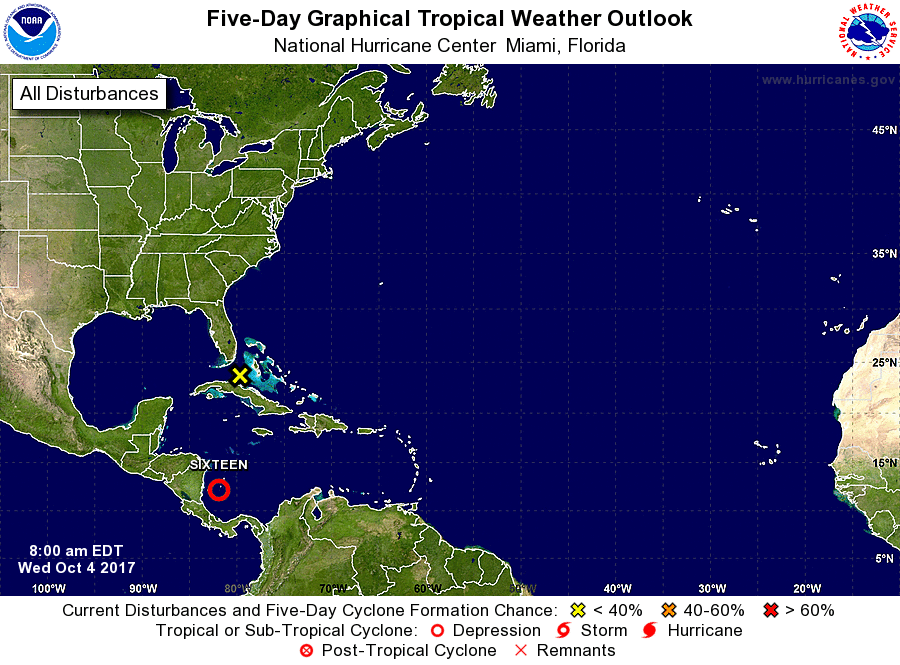
1. Showers and thunderstorms associated with an area of low pressure
located over the southwestern Caribbean Sea have become better
organized since yesterday. This system is expected to become a
tropical depression later today while it moves northwestward toward
the coast of Nicaragua. The low should move slowly northwestward
across or near the eastern portions of Nicaragua and Honduras on
Thursday, move into the northwestern Caribbean Sea by Friday, and
emerge over the southern Gulf of Mexico by Saturday. Interests in
Nicaragua, Honduras, the Yucatan peninsula and western Cuba should
monitor the progress of this system as watches or warnings could be
issued later today. An Air Force Reserve reconnaissance aircraft is
scheduled to investigate the disturbance this afternoon. Regardless
of development, this system will produce heavy rains over portions
of Central America during the next few days, likely causing flash
floods and mudslides.
* Formation chance through 48 hours...high...90 percent.
* Formation chance through 5 days...high...90 percent.
2. A trough of low pressure located over west-central Cuba and
extending northward into the Straits of Florida is producing a broad
area of disorganized showers and thunderstorms across the southern
peninsula of Florida, the northwestern Bahamas, and the adjacent
Atlantic waters. Although significant tropical development of this
system is not expected due to strong upper-level winds, brief
squalls will likely produce locally heavy rainfall and strong gusty
winds over portions of the Bahamas and the southern Florida
peninsula during the next couple of days.
* Formation chance through 48 hours...low...near 0 percent.
* Formation chance through 5 days...low...near 0 percent.
Forecaster Blake