ZCZC MIATWOAT ALL
TTAA00 KNHC DDHHMM
Tropical Weather Outlook
NWS National Hurricane Center Miami FL
200 AM EDT Wed Oct 4 2017
For the North Atlantic...Caribbean Sea and the Gulf of Mexico:
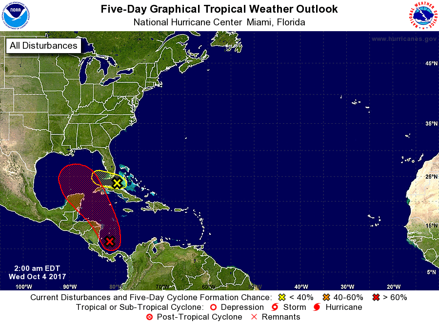
1. Showers and thunderstorms associated with the broad area of low
pressure located over the southwestern Caribbean Sea continue to
show signs of organization. Environmental conditions are forecast
to steadily become more conducive for development, and this system
is expected to become a tropical depression within the next couple
of days. The large disturbance should move slowly northwestward
across or near the eastern portions of Nicaragua and Honduras, move
into the northwestern Caribbean Sea on Thursday, and emerge over
the southern Gulf of Mexico by the weekend. Interests in Nicaragua,
Honduras, Belize, and the Yucatan peninsula should monitor the
progress of this system over the next few days. An Air Force
Reserve reconnaissance aircraft is scheduled to investigate the
disturbance this afternoon, if necessary. Regardless of
development, this system will likely produce heavy rains over
portions of Central America during the next few days.
* Formation chance through 48 hours...high...70 percent.
* Formation chance through 5 days...high...80 percent.
2. A trough of low pressure located over central Cuba and extending
northward into the Straits of Florida is producing a broad area
of disorganized showers and thunderstorms across the southern
peninsula of Florida, the northwestern Bahamas, and the adjacent
Atlantic waters. Although significant development of this system
is not expected due to strong upper-level winds, brief squalls will
likely produce locally heavy rainfall and strong gusty winds over
portions of the Bahamas and the southern Florida peninsula during
the next couple of days.
* Formation chance through 48 hours...low...10 percent.
* Formation chance through 5 days...low...10 percent.
Forecaster Stewart