ZCZC MIATWOAT ALL
TTAA00 KNHC DDHHMM
Tropical Weather Outlook
NWS National Hurricane Center Miami FL
800 AM EDT Fri Sep 29 2017
For the North Atlantic...Caribbean Sea and the Gulf of Mexico:
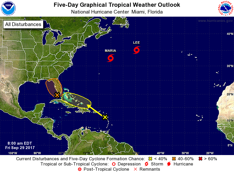
The National Hurricane Center is issuing advisories on Tropical
Storm Maria, located over the western Atlantic Ocean a few hundred
miles south of Halifax, Nova Scotia, and on Hurricane Lee, located
over the north Atlantic Ocean several hundred miles south-southeast
of Newfoundland.
1. A broad trough of low pressure interacting with an upper-level
low is producing a large but disorganized area of cloudiness and
showers. This activity extends from the northwestern Caribbean
Sea northward across western Cuba to the southern Florida peninsula.
This trough has moved slowly westward since yesterday, and a weak
low is now likely to form from this system near the west coast of
Florida during the weekend. Environmental conditions appear to be
conducive for some development of the low before the upper-level
winds become less favorable early next week. Regardless of
development, this system is likely to produce locally heavy rainfall
over portions of central and western Cuba, the Florida Keys, the
Florida peninsula during the next several days.
* Formation chance through 48 hours...medium...40 percent.
* Formation chance through 5 days...medium...40 percent.
2. A tropical wave is producing cloudiness and showers over the
northeastern Caribbean Sea and the adjacent Atlantic waters.
Although there are no signs of organization and surface pressures
are not falling at this time, conditions could become a little more
favorable for some development next week while the system moves
toward the west-northwest. This system is expected to bring
locally heavy rains over the northern Leeward Islands, including
Puerto Rico and the U.S. Virgin Islands.
* Formation chance through 48 hours...low...near 0 percent.
* Formation chance through 5 days...low...20 percent.
Forecaster Avila