ZCZC MIATWOAT ALL
TTAA00 KNHC DDHHMM
Tropical Weather Outlook
NWS National Hurricane Center Miami FL
800 PM EDT Tue Aug 22 2017
For the North Atlantic...Caribbean Sea and the Gulf of Mexico:
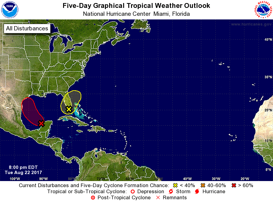
1. Satellite images and surface observations indicate that the area of
low pressure associated with the remnants of Harvey is moving off
the coast of the Yucatan Peninsula into the southern Gulf of
Mexico. Environmental conditions are conducive for a tropical
depression or tropical storm to form on Wednesday or Thursday
while the low moves northwestward at about 10 mph across the
western Gulf of Mexico, possibly reaching the northwestern Gulf
coast on Friday. Regardless of development, this system is likely
to slow down once it reaches the coast, increasing the threat of a
prolonged period of heavy rainfall and flooding across portions of
Texas, southwestern Louisiana, and northeastern Mexico into early
next week. This system could also produce storm surge and tropical
storm or hurricane force winds along portions of the Texas coast
later this week, and interests from northeastern Mexico to
southwestern Louisiana should continue to monitor its progress.
Please refer to products from your local National Weather Service
office for more information on this system.
* Formation chance through 48 hours...high...90 percent.
* Formation chance through 5 days...high...near 100 percent.
2. A large area of disorganized showers and thunderstorms stretching
across the Bahamas, Florida, and the adjacent waters is associated
with a trough of low pressure. Any development of this system
during the next few days should be slow to occur while it drifts
northward over Florida and the adjacent waters. Environmental
conditions could become a little more conducive for tropical or
subtropical development by the weekend when the system begins to
move northeastward over the western Atlantic. Regardless of
development, very heavy rain and flooding is possible over portions
of the Florida peninsula during the next few days. Please refer to
products from your local National Weather Service office for more
information on this system.
* Formation chance through 48 hours...low...10 percent.
* Formation chance through 5 days...low...30 percent.
Forecaster Berg