ZCZC MIATWOAT ALL
TTAA00 KNHC DDHHMM
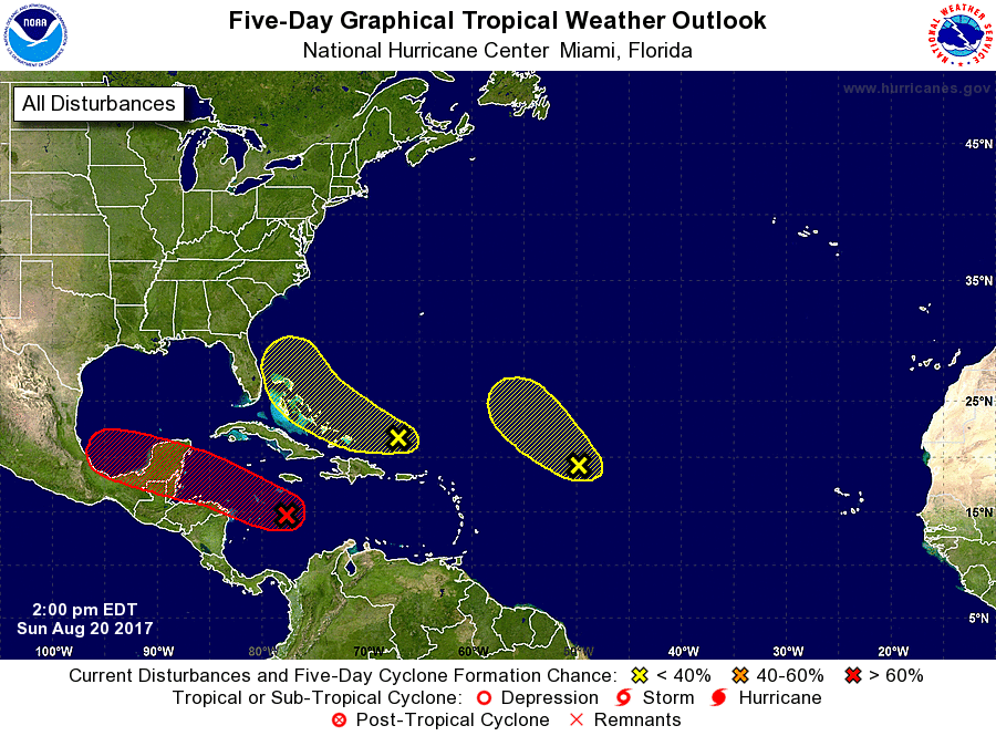
Tropical Weather Outlook
NWS National Hurricane Center Miami FL
200 PM EDT Sun Aug 20 2017
For the North Atlantic...Caribbean Sea and the Gulf of Mexico:
1. Satellite images indicate that showers and thunderstorms are
showing some signs of organization in association with the remnants
of Harvey, but it is still unclear if the system has a closed
circulation. Gradual development of this system is possible, and it
could become a tropical cyclone once again while it moves
west-northwestward across the northwestern Caribbean Sea and the
Yucatan Peninsula during the next couple of days, and into the Bay
of Campeche by midweek. Interests in northern Nicaragua, Honduras,
Belize, and the Yucatan Peninsula should monitor the progress of
this system. An Air Force Reserve reconnaissance aircraft is
currently enroute and should provide a better assessment of the
structure of this system.
* Formation chance through 48 hours...medium...50 percent
* Formation chance through 5 days...high...70 percent
2. Satellite data indicate that a trough of low pressure located a
couple of hundred miles north of the Dominican Republic is
producing disorganized showers and thunderstorms, with some strong
winds on its northeast side. Environmental conditions are expected
to be unfavorable for development of this system during the next day
or two, but they could become slightly more conducive for
development by midweek when the system is near the northwestern
Bahamas or Florida. This system is expected to move
west-northwestward at 15 to 20 mph during the next few days.
* Formation chance through 48 hours...low...10 percent.
* Formation chance through 5 days...low...30 percent.
3. A large area of cloudiness and disorganized thunderstorms located
about 900 miles east of the northern Leeward Islands is associated
with a trough of low pressure. This system is currently embedded in
a dry air mass, and upper-level winds are expected to become too
strong to support development in a day or so. Therefore,
tropical cyclone formation is not likely while this system moves
northwestward at about 15 mph.
* Formation chance through 48 hours...low...10 percent.
* Formation chance through 5 days...low...10 percent.
Forecaster Cangialosi