ZCZC MIATWOAT ALL
TTAA00 KNHC DDHHMM
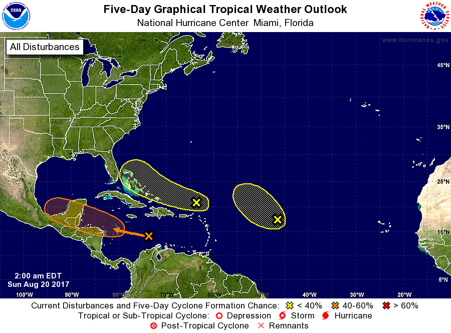
Tropical Weather Outlook
NWS National Hurricane Center Miami FL
200 AM EDT Sun Aug 20 2017
For the North Atlantic...Caribbean Sea and the Gulf of Mexico:
The National Hurricane Center has issued the last advisory on
Harvey, which has degenerated into a tropical wave over the
central Caribbean Sea.
1. Disorganized showers and thunderstorms over the central Caribbean
Sea are associated with the remnants of Harvey. Unfavorable
upper-level winds and dry air are expected to inhibit development
today. Environmental conditions could become a little more
conducive for regeneration by Monday when the system moves
west-northwestward over the northwest Caribbean Sea, and interests
in northern Nicaragua, Honduras, Belize, and the Yucatan peninsula
should monitor the progress of this system.
* Formation chance through 48 hours...low...30 percent
* Formation chance through 5 days...medium...40 percent
2. A trough of low pressure located a couple of hundred miles north of
the Leeward Islands continues to produce disorganized showers and
thunderstorms. Environmental conditions are not expected to be
conducive for development of this system during the next couple of
days while it moves west-northwestward at 15 to 20 mph. Conditions
could become slightly more conducive for development once the system
is near the northern Bahamas or Florida later this week.
* Formation chance through 48 hours...low...10 percent.
* Formation chance through 5 days...low...20 percent.
3. A large area of cloudiness and disorganized thunderstorms located
about 1000 miles east of the Leeward Islands is associated with a
trough of low pressure. The system is currently embedded in a dry
air mass, and upper-level winds are expected to become too strong to
support development in a couple of days. Therefore, tropical
cyclone formation is not likely while this system moves
northwestward at about 15 mph.
* Formation chance through 48 hours...low...10 percent.
* Formation chance through 5 days...low...10 percent.
Forecaster Brown