ZCZC MIATWOAT ALL
TTAA00 KNHC DDHHMM
Tropical Weather Outlook
NWS National Hurricane Center Miami FL
800 PM EDT Sat Aug 5 2017
For the North Atlantic...Caribbean Sea and the Gulf of Mexico:
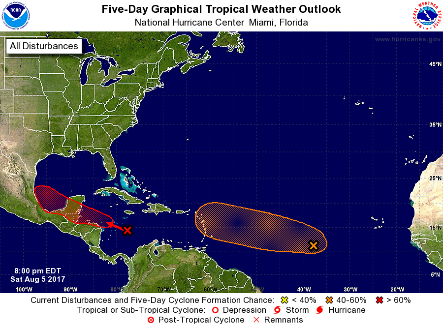
1. Showers and thunderstorms associated with a strong tropical wave
located over the central Caribbean Sea are showing signs of
organization. Additional development of this system is possible
while it moves west-northwestward at 10 to 15 mph, and a tropical
depression or tropical storm could form over the northwestern
Caribbean Sea before it reaches the Yucatan peninsula late Monday or
Tuesday. Even if formation does not occur before the system
reaches the Yucatan peninsula, a tropical depression or tropical
storm could form over the Bay of Campeche during the middle part of
next week. Development would likely not occur if the system moves
inland over Central America and southeastern Mexico and does not
re-emerge over water. An Air Force Reserve reconnaissance aircraft
is scheduled to investigate this system tomorrow afternoon, if
necessary. Interests along the coasts of Honduras, Belize, and the
Yucatan peninsula of Mexico should monitor the progress of this
disturbance.
* Formation chance through 48 hours...medium...50 percent.
* Formation chance through 5 days...high...70 percent.
2. Shower activity associated with an elongated area of low pressure
located about 1000 miles west-southwest of the Cabo Verde Islands
has become a little better organized during the past 24 hours.
Some additional slow development is possible during the next two to
three days before the system encounters less favorable
environmental conditions during the middle part of next week. This
system is expected to move generally west-northwestward across the
tropical Atlantic Ocean at about 15 mph.
* Formation chance through 48 hours...low...30 percent.
* Formation chance through 5 days...medium...50 percent.
Forecaster Beven