ZCZC MIATWOAT ALL
TTAA00 KNHC DDHHMM
Tropical Weather Outlook
NWS National Hurricane Center Miami FL
800 PM EDT Sun Jun 18 2017
For the North Atlantic...Caribbean Sea and the Gulf of Mexico:
The National Hurricane Center is issuing advisories on Potential
Tropical Cyclone Two, located several hundred miles east-southeast
of the southern Windward Islands.
* Formation chance through 48 hours...high...90 percent.
* Formation chance through 5 days...high...90 percent.
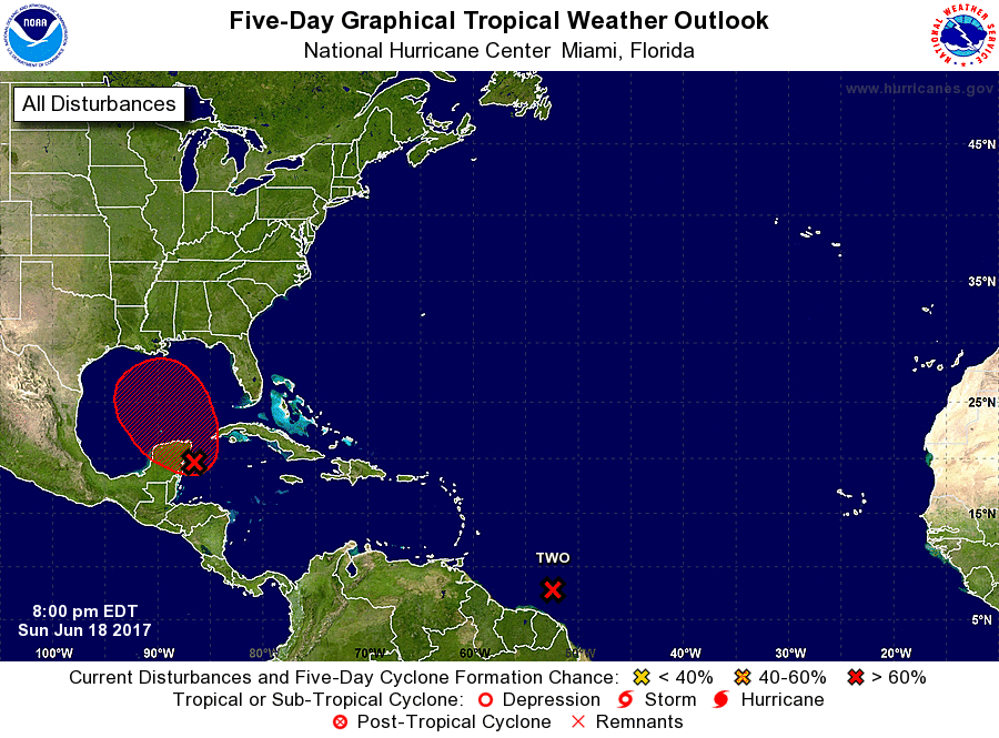
1. A broad area of low pressure located near the east coast of the
Yucatan Peninsula continues to produce a large area of disorganized
showers and thunderstorms along with winds to gale force several
hundred miles to the east and northeast of the center. Although
surface pressures are falling over the northwestern Caribbean Sea,
the low still lacks a well-defined center of circulation. However,
gradual development of this system is expected while it moves
slowly north-northwestward across the Yucatan Peninsula overnight,
and then over the southern or central Gulf of Mexico on Monday and
Tuesday, where a tropical or subtropical cyclone is likely to form.
Regardless of development, heavy rains are expected to continue over
portions of Central America, the Yucatan Peninsula, Jamaica, the
Cayman Islands, and western Cuba during the next few days. An Air
Force Reserve Hurricane Hunter aircraft is scheduled to investigate
this system on Monday, if necessary. For more information on this
system, please see the High Seas Forecast issued by the Tropical
Analysis and Forecast Branch.
* Formation chance through 48 hours...high...80 percent.
* Formation chance through 5 days...high...90 percent.
Public Advisories on Potential Tropical Cyclone Two are issued under
WMO header WTNT32 KNHC and under AWIPS header MIATCPAT2.
Forecast/Advisories on Potential Tropical Cyclone Two are issued
under WMO header WTNT22 KNHC and under AWIPS header MIATCMAT2.
High Seas Forecasts issued by the National Weather Service can be
found under AWIPS header NFDHSFAT1, WMO header FZNT01 KWBC, and
on the Web at http://www.opc.ncep.noaa.gov/shtml/NFDHSFAT1.shtml.
Forecaster Cangialosi/Stewart