ZCZC MIATWOAT ALL
TTAA00 KNHC DDHHMM
Tropical Weather Outlook
NWS National Hurricane Center Miami FL
200 PM EDT Sat Jun 17 2017
For the North Atlantic...Caribbean Sea and the Gulf of Mexico:
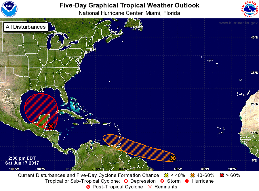
1. A tropical wave located about 1400 miles east-southeast of the
southern Windward Islands is producing scattered showers and
thunderstorms. This disturbance has changed little in organization
since yesterday. However, some development is expected during the
next two to three days before conditions become less favorable for
tropical cyclone formation. This system is forecast to move toward
the west or west-northwest at 15 to 20 mph over the tropical
Atlantic toward the Windward Islands and northeastern South America
during the next several days.
* Formation chance through 48 hours...medium...40 percent.
* Formation chance through 5 days...medium...60 percent.
2. Satellite data and surface observations indicate that a broad low
pressure area has formed over the Gulf of Honduras, and the
associated shower activity is showing signs of organization.
Continued gradual development is expected as the system moves slowly
northwestward across the Yucatan Peninsula during the remainder of
the weekend, and a tropical cyclone is likely to form early next
week over the southern or central Gulf of Mexico. Regardless of
development, heavy rains are likely to spread over portions of
Central America, the Yucatan Peninsula, Jamaica, the Cayman Islands,
and western Cuba during the next several days. An Air Force Reserve
Hurricane Hunter aircraft is scheduled to investigate this system on
Sunday, if necessary.
* Formation chance through 48 hours...low...30 percent.
* Formation chance through 5 days...high...80 percent.
Forecaster Beven