Skip Navigation Links
NOAA NOAA United States Department of Commerce

NHC Graphical Outlook Archive


« Earliest Available         ‹ Earlier         Later ›         Latest Available »
GIS Shapefiles
tab Eastern North Pacific tab tab Atlantic tab

View 2-Day Graphical Tropical Weather Outlook
Click for Eastern North Pacific Click for Eastern North Pacific

Tropical Weather Outlook Text

ZCZC MIATWOAT ALL
TTAA00 KNHC DDHHMM

TROPICAL WEATHER OUTLOOK
NWS NATIONAL HURRICANE CENTER MIAMI FL
700 PM EST FRI NOV 18 2016

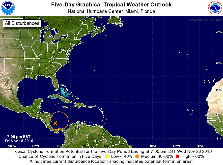
For the North Atlantic...Caribbean Sea and the Gulf of Mexico:

1. Disorganized cloudiness and showers over the southwestern Caribbean
Sea are associated with a broad low pressure area.  Upper-level
winds are expected to be only marginally conducive for development
over the next couple of days.  After that time, environmental
conditions are expected to be more conducive for gradual
development, and a tropical depression could still form early next
week while the low moves slowly and erratically.
* Formation chance through 48 hours...low...near 0 percent
* Formation chance through 5 days...medium...50 percent

Forecaster Pasch


List of Atlantic Outlooks (May 2023 - present)
List of East Pacific Outlooks (May 2023 - present)
List of Central Pacific Outlooks (May 2023 - present)
List of Atlantic Outlooks (July 2014 - April 2023)
List of East Pacific Outlooks (July 2014 - April 2023)
List of Central Pacific Outlooks (June 2019 - April 2023)
List of Atlantic Outlooks (June 2009 - June 2014)
List of East Pacific Outlooks (June 2009 - June 2014)