ZCZC MIATWOAT ALL
TTAA00 KNHC DDHHMM
TROPICAL WEATHER OUTLOOK
NWS NATIONAL HURRICANE CENTER MIAMI FL
200 AM EDT WED SEP 28 2016
For the North Atlantic...Caribbean Sea and the Gulf of Mexico:
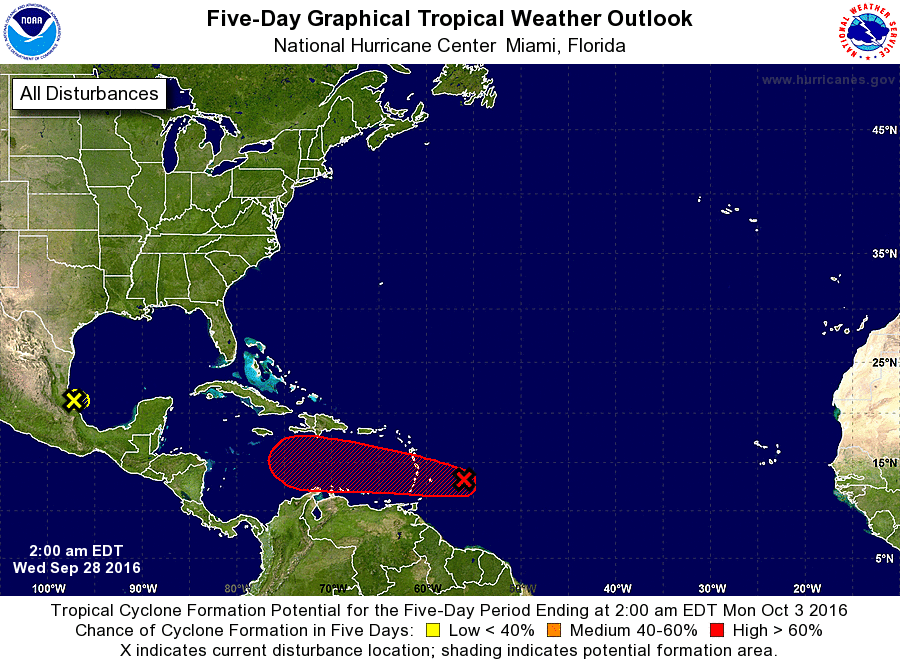
A strong tropical wave is located about 170 miles east of Barbados.
This disturbance is producing winds to near tropical storm force,
and the associated thunderstorm activity continues to show signs
of organization. Conditions are expected to be favorable for
development, and a tropical depression or tropical storm is likely
to form later today. The system is moving westward to
west-northwestward at 15 to 20 mph, and is expected to pass over
the Windward Islands later today, and move over the southeastern
Caribbean Sea tonight and Thursday. An Air Force Reserve
reconnaissance aircraft is scheduled to investigate the system
again later this morning.
1. Interests in the Windward and southern Leeward Islands, Bonaire,
Curacao, Aruba, and along the northern coast of South America
should monitor the progress of this disturbance, and consult
products issued by your national meteorological service, which
could include tropical storm warnings or watches. Regardless of
whether the system is a tropical wave or a tropical cyclone, heavy
rains and tropical-storm-force winds in squalls are expected to
spread over the Windward Islands and portions of the southern
Leeward Islands, beginning this morning and continuing through
tonight and early Thursday.
* Formation chance through 48 hours...high...90 percent
* Formation chance through 5 days...high...90 percent
2. A large area of disorganized showers and thunderstorms over the
southwestern Gulf of Mexico just to the southeast of Tampico,
Mexico, is associated with a weak low pressure system that is
drifting westward. Proximity to land and unfavorable upper-level
winds are expected to inhibit any significant development before
this disturbance moves inland over Mexico during the next day or so.
* Formation chance through 48 hours...low...10 percent
* Formation chance through 5 days...low...10 percent
Forecaster Stewart