ZCZC MIATWOAT ALL
TTAA00 KNHC DDHHMM
TROPICAL WEATHER OUTLOOK
NWS NATIONAL HURRICANE CENTER MIAMI FL
200 PM EDT MON SEP 26 2016
For the North Atlantic...Caribbean Sea and the Gulf of Mexico:
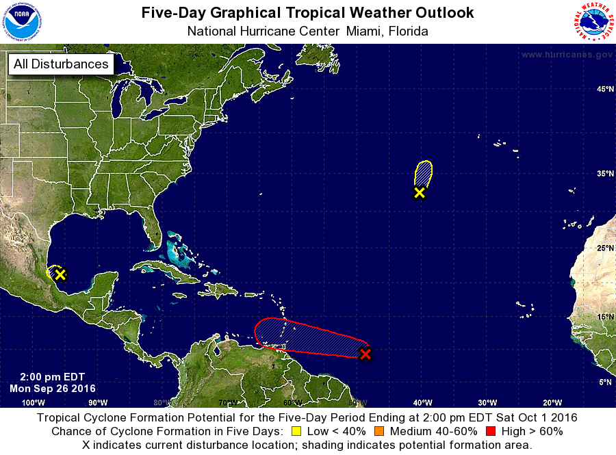
1. Showers and thunderstorms associated with a broad area of low
pressure pressure located about 950 miles east-southeast of the
Windward Islands have increased and become slightly better
organized since yesterday. Environmental conditions remain
conducive for development, and a tropical depression is likely to
form during the next day or two while the system moves westward to
west-northwestward at 15 to 20 mph. Interests in the eastern and
central Caribbean Sea, including the northern coast of South
America, should monitor the progress of this system. Regardless of
development, heavy rains and strong gusty winds, possibly to
tropical storm force, are expected to spread over the Windward
Islands and portions of the southern Lesser Antilles beginning
late Tuesday or Wednesday. An Air Force Hurricane Hunter aircraft is
scheduled to investigate this disturbance on Tuesday afternoon.
* Formation chance through 48 hours...high...70 percent
* Formation chance through 5 days...high...90 percent
2. Shower activity has redeveloped in association with the remnants of
Lisa, located about 700 miles southwest of the Azores. This system
is expected to merge with a cold front on Tuesday before
regeneration into a tropical cyclone can occur.
* Formation chance through 48 hours...low...10 percent
* Formation chance through 5 days...low...10 percent
3. Widespread cloudiness and thunderstorms over the southwestern Gulf
of Mexico are associated with a trough of low pressure that is
drifting westward. Upper-level winds are not expected to be
conducive for significant development before this system moves
inland over northeastern Mexico.
* Formation chance through 48 hours...low...10 percent
* Formation chance through 5 days...low...10 percent
Forecaster Kimberlain