ZCZC MIATWOAT ALL
TTAA00 KNHC DDHHMM
TROPICAL WEATHER OUTLOOK
NWS NATIONAL HURRICANE CENTER MIAMI FL
200 PM EDT FRI SEP 9 2016
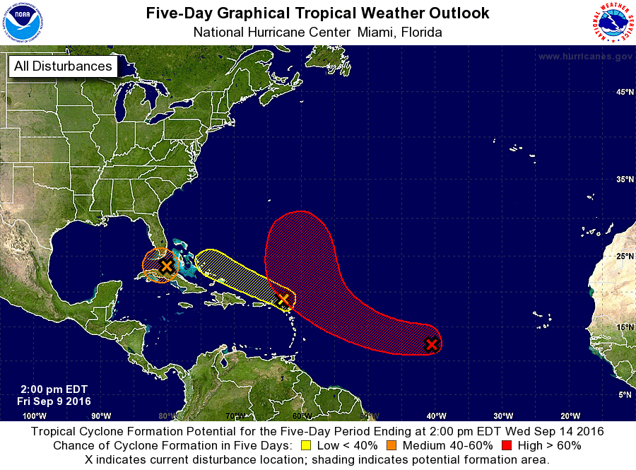
For the North Atlantic...Caribbean Sea and the Gulf of Mexico:
1. A large area of disturbed weather associated with a westward-moving
tropical wave is located a little more than 1000 miles east of
the Lesser Antilles. This system is gradually becoming better
organized, and conditions are forecast to be favorable for a
tropical depression to form this weekend or early next week. This
disturbance is expected to move toward the west-northwest and then
northwest over the central Atlantic during the next several days.
* Formation chance through 48 hours...medium...50 percent
* Formation chance through 5 days...high...80 percent
2. Cloudiness and showers located just north of the northern Leeward
Islands and Puerto Rico are spreading west-northwestward with no
signs of organization. Environmental conditions are not expected to
be conducive for significant development.
* Formation chance through 48 hours...low...10 percent
* Formation chance through 5 days...low...10 percent
3. Satellite wind data indicate that low pressure located in the
Straits of Florida is producing squalls of 30 to 35 mph east of its
center. If the system's thunderstorm activity persists or increases
in organization, it could result in the formation of a tropical
depression later today or Saturday. However, even if a depression
forms, upper-level winds are not favorable for significant
development while the system moves westward into the southeastern
Gulf of Mexico. This system could produce squalls and gusty winds
in the Florida Keys tonight and Saturday.
* Formation chance through 48 hours...medium...40 percent
* Formation chance through 5 days...medium...40 percent
Forecaster Avila