ZCZC MIATWOAT ALL
TTAA00 KNHC DDHHMM
TROPICAL WEATHER OUTLOOK
NWS NATIONAL HURRICANE CENTER MIAMI FL
200 PM EDT SUN AUG 28 2016
For the North Atlantic...Caribbean Sea and the Gulf of Mexico:
The National Hurricane Center is issuing advisories on Hurricane
Gaston, located about 600 miles east of Bermuda, and on newly
formed Tropical Depression Eight, located about 400 miles southeast
of Cape Hatteras, North Carolina.
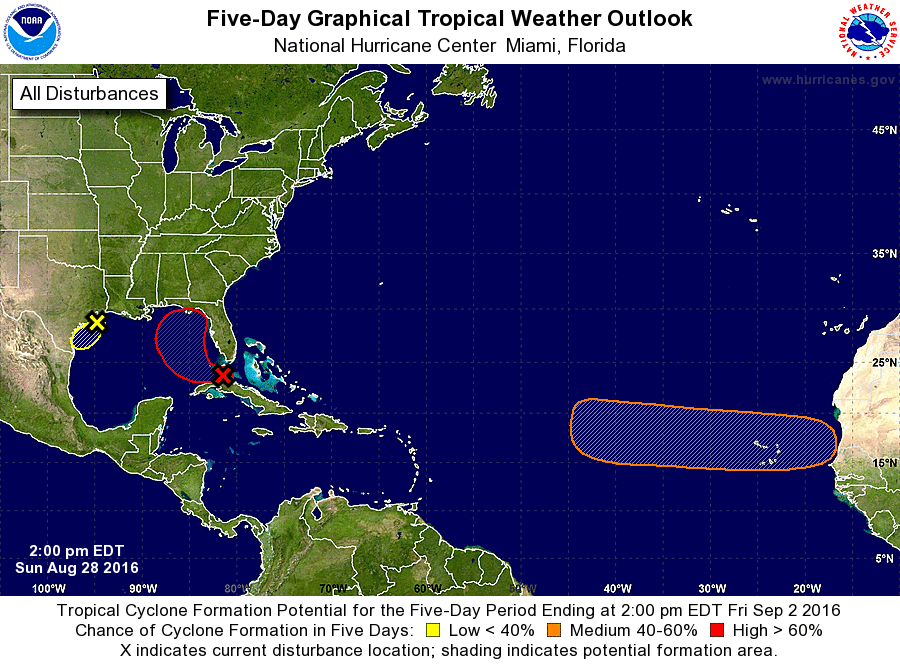
1. Shower and thunderstorm activity has begun to increase near and to
the east of a weak area of low pressure located just south of the
lower Florida Keys. The low is expected to move westward into the
southeastern Gulf of Mexico on Monday, where environmental
conditions are expected to become more conducive for development,
and a tropical depression is likely to form within the next few
days. This system is then expected to move slowly northward and
northeastward over the eastern Gulf of Mexico later this week.
Regardless of development, heavy rainfall and gusty winds are likely
to continue over portions of the northwestern Bahamas, central and
western Cuba, the Florida Keys and portions of southern Florida
through Monday. Interests elsewhere in Florida and the eastern Gulf
of Mexico should continue to monitor the progress of this
disturbance.
* Formation chance through 48 hours...medium...60 percent
* Formation chance through 5 days...high...80 percent
2. A weak area of low pressure located near the upper Texas coast is
producing disorganized shower and thunderstorm activity over the
northwestern Gulf of Mexico and adjacent coastal areas of
southwestern Louisiana and southeastern Texas. Surface pressures
remain high in the area and the system's proximity to land is
expected to limit significant development while it moves slowly
southwestward during the next couple of days. For additional
information on the rainfall associated with this system, please see
products from your local National Weather Service office.
* Formation chance through 48 hours...low...10 percent
* Formation chance through 5 days...low...10 percent
3. A tropical wave is expected to move offshore of the west coast of
Africa on Tuesday. Conditions are expected to be favorable for
development of this system later this week while it moves westward
at 15 to 20 mph over the tropical eastern Atlantic.
* Formation chance through 48 hours...low...near 0 percent
* Formation chance through 5 days...medium...50 percent
Public Advisories on Tropical Depression Eight are issued under WMO
header WTNT33 KNHC and under AWIPS header MIATCPAT3.
Forecast/Advisories on Tropical Depression Eight are issued under
WMO header WTNT23 KNHC and under AWIPS header MIATCMAT3.
Forecaster Brennan