ZCZC MIATWOAT ALL
TTAA00 KNHC DDHHMM
TROPICAL WEATHER OUTLOOK
NWS NATIONAL HURRICANE CENTER MIAMI FL
200 AM EDT SUN AUG 28 2016
For the North Atlantic...Caribbean Sea and the Gulf of Mexico:
The National Hurricane Center is issuing advisories on Tropical
Storm Gaston, located about several hundred miles east-southeast
of Bermuda.
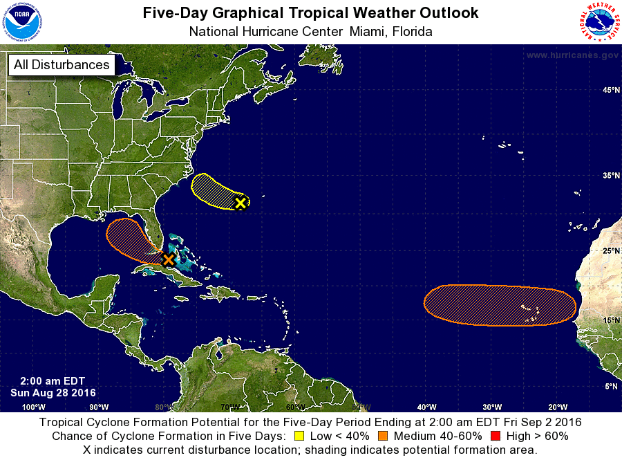
1. A weak area of low pressure located near the north coast of central
Cuba is producing a large but disorganized area of cloudiness and
thunderstorms. Upper-level winds are not conducive for significant
development today while this system moves westward through the
Straits of Florida. The low is expected to move into the
southeastern Gulf of Mexico on Monday, where environmental
conditions are forecast to a little more conducive for development.
Regardless of development, heavy rainfall and gusty winds are likely
over portions of the central and northwestern Bahamas, and Cuba
through tonight. Gusty winds and locally heavy rainfall will spread
into parts of southern Florida and the Florida Keys later today.
Interests elsewhere in Florida and the eastern Gulf of Mexico should
continue to monitor the progress of this disturbance. A NOAA
Hurricane Hunter aircraft is scheduled to investigate this system
this afternoon, if necessary.
* Formation chance through 48 hours...medium...40 percent
* Formation chance through 5 days...medium...60 percent
2. Shower activity associated with an area of low pressure located
about 200 miles west-southwest of Bermuda remains poorly organized.
Any development of this system should be slow to occur due to the
proximity of dry air during the next couple of days. This low is
forecast to move westward and then west-northwestward at about 10
mph toward the coast of North Carolina where conditions are not
favorable for development. For additional information on this
system, see High Seas Forecasts issued by the National Weather
Service.
* Formation chance through 48 hours...low...30 percent
* Formation chance through 5 days...low...30 percent
3. A tropical wave is expected to move offshore of the west coast of
Africa on Tuesday. Conditions are expected to be favorable for
development of this system later this week while it moves
westward at 15 to 20 mph over the tropical eastern Atlantic.
* Formation chance through 48 hours...low...near 0 percent
* Formation chance through 5 days...medium...50 percent
High Seas Forecasts issued by the National Weather Service can be
found under AWIPS header NFDHSFAT1, WMO header FZNT01 KWBC, and
on the Web at http://www.opc.ncep.noaa.gov/shtml/NFDHSFAT1.shtml.
Forecaster Brown