ZCZC MIATWOAT ALL
TTAA00 KNHC DDHHMM
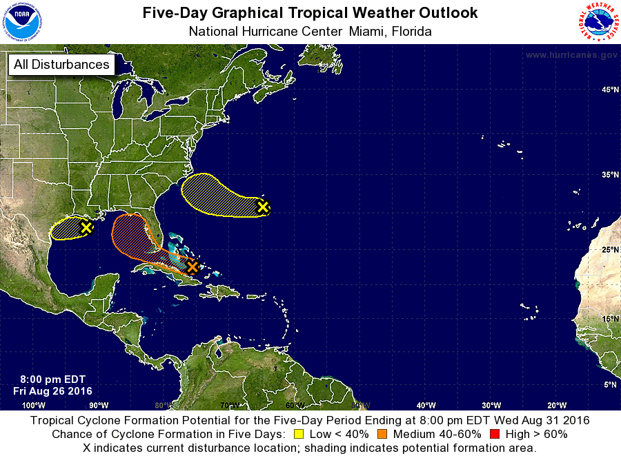
TROPICAL WEATHER OUTLOOK
NWS NATIONAL HURRICANE CENTER MIAMI FL
800 PM EDT FRI AUG 26 2016
For the North Atlantic...Caribbean Sea and the Gulf of Mexico:
The National Hurricane Center is issuing advisories on Tropical
Storm Gaston, located about 1000 miles east-southeast of Bermuda.
1. Shower activity associated with a weak area of low pressure located
in the central Bahamas has increased during the past several hours
but it remains disorganized. Upper-level winds are not favorable
for significant development during the next day or so while the
system moves west-northwestward at about 10 mph. Environmental
conditions could become a little more conducive for some development
when the system reaches the eastern Gulf of Mexico early next week.
Heavy rains, with the potential to cause flash floods and mud
slides, are likely to continue over Hispaniola tonight and Saturday.
This activity is expected to spread over eastern and central Cuba
through the weekend. Gusty winds and locally heavy rainfall are
likely over portions of the Bahamas, and will spread into parts of
southern Florida and the Florida Keys over the weekend. Interests
elsewhere in Florida and the eastern Gulf of Mexico should continue
to monitor the progress of this disturbance.
* Formation chance through 48 hours...low...20 percent
* Formation chance through 5 days...medium...50 percent
2. Disorganized shower and thunderstorm activity located over the
north-central Gulf of Mexico is associated with a weak trough of
low pressure. Conditions are not expected to be favorable for
development before it reaches the coast of Texas over the weekend.
This disturbance could produce heavy rainfall along the Gulf Coast
from Louisiana to southeastern Texas during the next couple of days.
For additional information, please see products from your local
National Weather Service office.
* Formation chance through 48 hours...low...10 percent
* Formation chance through 5 days...low...10 percent
3. An area of disturbed weather, associated with a broad area of low
pressure, has formed a couple of hundred miles south of Bermuda.
Little motion is anticipated during the next two days, and a
slow westward heading should begin thereafter. Development of
this system, if any, is likely to be slow to occur due to this
system's proximity to dry air.
* Formation chance through 48 hours...low...10 percent
* Formation chance through 5 days...low...20 percent
Forecaster Avila