ZCZC MIATWOAT ALL
TTAA00 KNHC DDHHMM
TROPICAL WEATHER OUTLOOK
NWS NATIONAL HURRICANE CENTER MIAMI FL
200 PM EDT MON AUG 22 2016
For the North Atlantic...Caribbean Sea and the Gulf of Mexico:
The National Hurricane Center is issuing advisories on Tropical
Depression Fiona, located several hundred miles north-northeast of
the Leeward Islands.
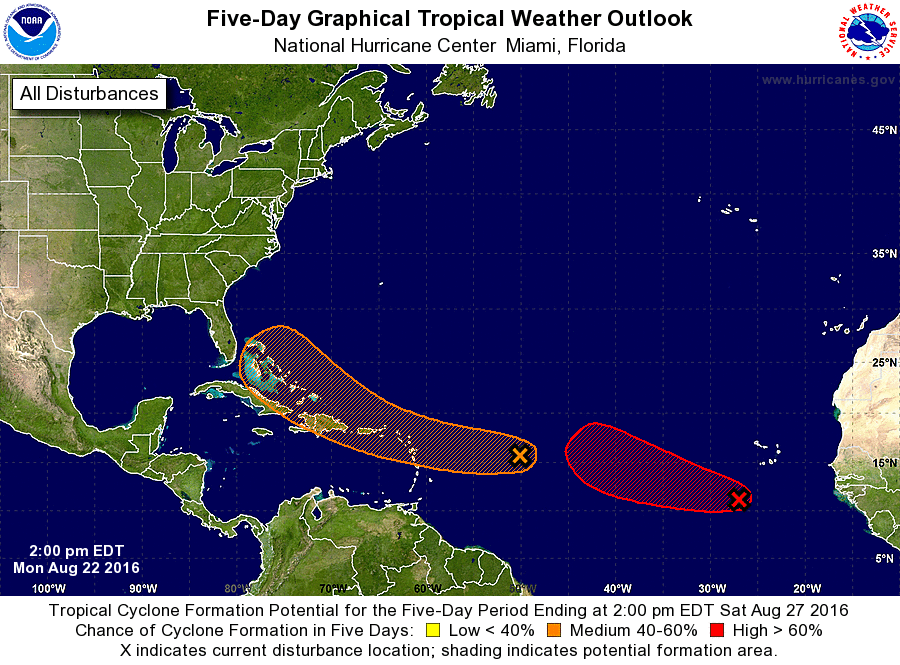
1. A tropical wave located about 750 miles east of the Lesser Antilles
is producing disorganized shower and thunderstorm activity. Nearby
dry air is expected to slow development during the next couple of
days while the disturbance moves westward to west-northwestward at
15 to 20 mph. Environmental conditions could become more conducive
for development late this week when the system is expected to move
near Hispaniola and the southeastern and central Bahamas. An Air
Force Reserve Hurricane Hunter aircraft is scheduled to investigate
this system on Tuesday, if necessary. Interests in the Lesser
Antilles, the Virgin Islands, and Puerto Rico should monitor the
progress of this system.
* Formation chance through 48 hours...low...20 percent
* Formation chance through 5 days...medium...50 percent
2. A low pressure area associated with a tropical wave is centered
about 300 miles southwest of the southern Cabo Verde Islands. The
associated showers and thunderstorms are well organized. However,
recent microwave satellite data suggests the system has not yet
developed a well-defined circulation. A tropical depression could
form at any time tonight or on Tuesday as the system moves westward
to west-northwestward at 15 to 20 mph over the eastern tropical
Atlantic Ocean.
* Formation chance through 48 hours...high...near 100 percent
* Formation chance through 5 days...high...near 100 percent
Forecaster Beven