Skip Navigation Links
NOAA NOAA United States Department of Commerce

NHC Graphical Outlook Archive


« Earliest Available         ‹ Earlier         Later ›         Latest Available »
GIS Shapefiles
tab Eastern North Pacific tab tab Atlantic tab

View 2-Day Graphical Tropical Weather Outlook
Click for Eastern North Pacific Click for Eastern North Pacific

Tropical Weather Outlook Text

ZCZC MIATWOAT ALL
TTAA00 KNHC DDHHMM

TROPICAL WEATHER OUTLOOK
NWS NATIONAL HURRICANE CENTER MIAMI FL
200 AM EDT TUE AUG 16 2016

For the North Atlantic...Caribbean Sea and the Gulf of Mexico:

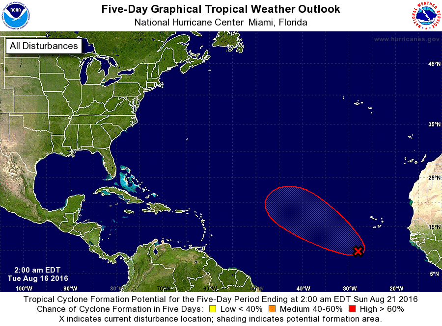
1. A large area of cloudiness and thunderstorms located about 450
miles southwest of the Cabo Verde Islands is associated with a
tropical wave.  Environmental conditions are expected to be
conducive for development, and a tropical depression is likely to
form during the next few days while the system moves
west-northwestward to northwestward toward the central tropical
Atlantic.
* Formation chance through 48 hours...medium...60 percent
* Formation chance through 5 days...high...70 percent

Forecaster Brown


List of Atlantic Outlooks (May 2023 - present)
List of East Pacific Outlooks (May 2023 - present)
List of Central Pacific Outlooks (May 2023 - present)
List of Atlantic Outlooks (July 2014 - April 2023)
List of East Pacific Outlooks (July 2014 - April 2023)
List of Central Pacific Outlooks (June 2019 - April 2023)
List of Atlantic Outlooks (June 2009 - June 2014)
List of East Pacific Outlooks (June 2009 - June 2014)