Skip Navigation Links
NOAA NOAA United States Department of Commerce

NHC Graphical Outlook Archive


« Earliest Available         ‹ Earlier         Later ›         Latest Available »
GIS Shapefiles
tab Eastern North Pacific tab tab Atlantic tab

View 2-Day Graphical Tropical Weather Outlook
Click for Eastern North Pacific Click for Eastern North Pacific

Tropical Weather Outlook Text

ZCZC MIATWOAT ALL
TTAA00 KNHC DDHHMM

TROPICAL WEATHER OUTLOOK
NWS NATIONAL HURRICANE CENTER MIAMI FL
800 AM EDT THU JUN 23 2016

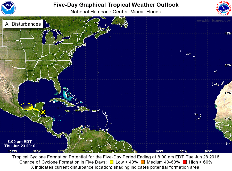
For the North Atlantic...Caribbean Sea and the Gulf of Mexico:

1. Disorganized showers and thunderstorms over the northwestern
Caribbean Sea are associated with a tropical wave and a weak low
pressure area.  Development of this system is not expected today
due to it moving over the Yucatan Peninsula and Belize later today.
Some development of this system is possible on Friday if the
system emerges over the Bay of Campeche before again moving inland
on Saturday.
* Formation chance through 48 hours...low...10 percent
* Formation chance through 5 days...low...10 percent

Forecaster Blake


List of Atlantic Outlooks (May 2023 - present)
List of East Pacific Outlooks (May 2023 - present)
List of Central Pacific Outlooks (May 2023 - present)
List of Atlantic Outlooks (July 2014 - April 2023)
List of East Pacific Outlooks (July 2014 - April 2023)
List of Central Pacific Outlooks (June 2019 - April 2023)
List of Atlantic Outlooks (June 2009 - June 2014)
List of East Pacific Outlooks (June 2009 - June 2014)