


NHC Graphical Outlook Archive
|
« Earliest Available ‹ Earlier Later › Latest Available » |
GIS Shapefiles |
| Eastern North Pacific | Atlantic |
|
Tropical Weather Outlook Text
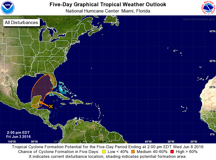
ZCZC MIATWOAT ALL
TTAA00 KNHC DDHHMM

TROPICAL WEATHER OUTLOOK
NWS NATIONAL HURRICANE CENTER MIAMI FL
200 PM EDT FRI JUN 3 2016

For the North Atlantic...Caribbean Sea and the Gulf of Mexico:

The National Hurricane Center is issuing advisories on Tropical
Depression Bonnie, located about 200 miles east-northeast of Cape
Hatteras, North Carolina.

1. A large area of showers and thunderstorms continues over the western
Caribbean Sea.  This system is moving west-northwestward toward the
Yucatan Peninsula of Mexico, and a low pressure area is expected to
form over the Yucatan or the adjacent waters over the weekend.
This low could develop into a tropical cyclone as it subsequently
moves across the eastern Gulf of Mexico and the Florida Peninsula
early next week.  Regardless of development, locally heavy rains and
flooding are possible over portions of the Yucatan Peninsula,
western Cuba and the Florida Peninsula during the next several days.
* Formation chance through 48 hours...low...20 percent
* Formation chance through 5 days...medium...60 percent

Forecaster Beven
List of Atlantic Outlooks (May 2023 - present)
List of East Pacific Outlooks (May 2023 - present)
List of Central Pacific Outlooks (May 2023 - present)
List of Atlantic Outlooks (July 2014 - April 2023)
List of East Pacific Outlooks (July 2014 - April 2023)
List of Central Pacific Outlooks (June 2019 - April 2023)
List of Atlantic Outlooks (June 2009 - June 2014)
List of East Pacific Outlooks (June 2009 - June 2014)