


NHC Graphical Outlook Archive
|
« Earliest Available ‹ Earlier Later › Latest Available » |
GIS Shapefiles |
| Eastern North Pacific | Atlantic |
|
Tropical Weather Outlook Text
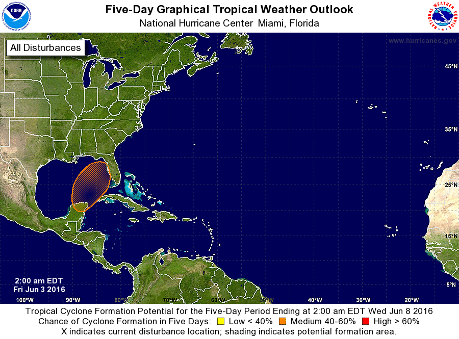
ZCZC MIATWOAT ALL
TTAA00 KNHC DDHHMM

TROPICAL WEATHER OUTLOOK
NWS NATIONAL HURRICANE CENTER MIAMI FL
200 AM EDT FRI JUN 3 2016

For the North Atlantic...Caribbean Sea and the Gulf of Mexico:

The National Hurricane Center is issuing advisories on Tropical
Depression Bonnie, located about 75 miles east-northeast of Cape
Hatteras, North Carolina.

1. A broad low pressure area is expected to form over the Yucatan
Peninsula of Mexico or the southern Gulf of Mexico by late this
weekend.  Although upper-level winds are not forecast to be
particularly conducive for tropical cyclone formation, additional
development of the low could occur when it moves generally
northeastward across the central and eastern Gulf of Mexico early
next week.  This system is likely to produce heavy rains and
possible flooding over portions of the Yucatan Peninsula, western
Cuba and the Florida peninsula.
* Formation chance through 48 hours...low...near 0 percent
* Formation chance through 5 days...medium...50 percent

Forecaster Kimberlain
List of Atlantic Outlooks (May 2023 - present)
List of East Pacific Outlooks (May 2023 - present)
List of Central Pacific Outlooks (May 2023 - present)
List of Atlantic Outlooks (July 2014 - April 2023)
List of East Pacific Outlooks (July 2014 - April 2023)
List of Central Pacific Outlooks (June 2019 - April 2023)
List of Atlantic Outlooks (June 2009 - June 2014)
List of East Pacific Outlooks (June 2009 - June 2014)