


NHC Graphical Outlook Archive
|
« Earliest Available ‹ Earlier Later › Latest Available » |
GIS Shapefiles |
| Eastern North Pacific | Atlantic |
|
Tropical Weather Outlook Text
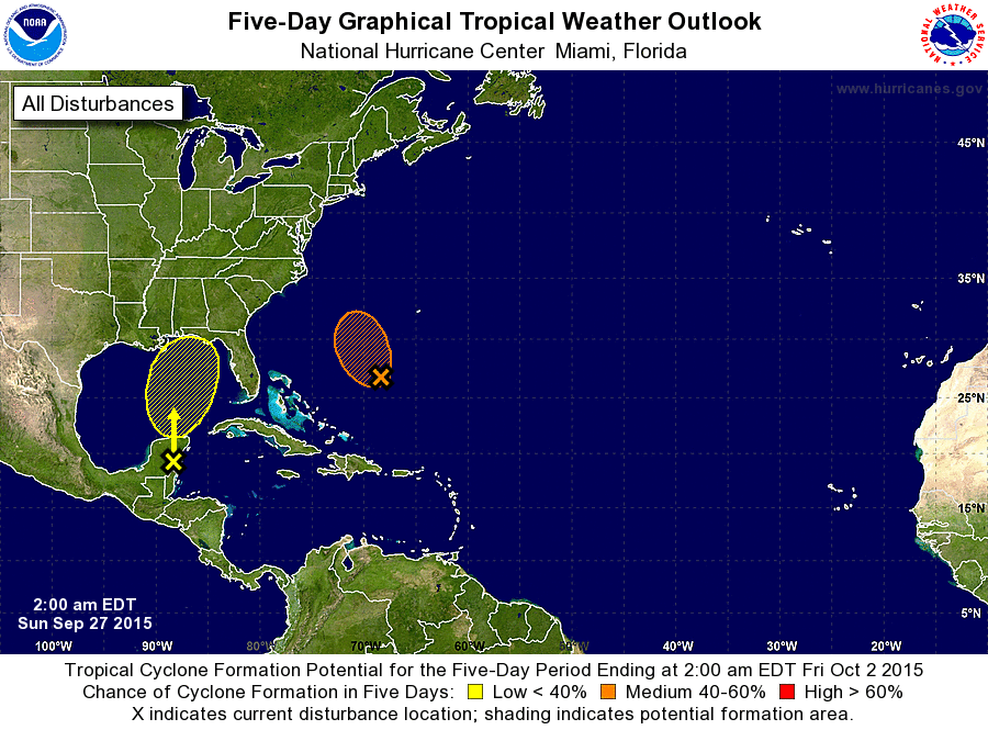
ZCZC MIATWOAT ALL
TTAA00 KNHC DDHHMM

TROPICAL WEATHER OUTLOOK
NWS NATIONAL HURRICANE CENTER MIAMI FL
200 AM EDT SUN SEP 27 2015

For the North Atlantic...Caribbean Sea and the Gulf of Mexico:

The National Hurricane Center is issuing advisories on Tropical
Depression Ida, located a little more than 1000 miles east-northeast
of the northern Leeward Islands.

1. An area of low pressure over the eastern Yucatan Peninsula and an
upper-level low pressure system over the western Gulf of Mexico
are producing a large area of disorganized cloudiness and showers
extending from the northwestern Caribbean Sea northward over the
eastern Gulf of Mexico.  Upper-level winds are expected to be only
marginally conducive for development as this system moves northward
toward the northern Gulf Coast during the next day or two.
Regardless of tropical cyclone formation, this disturbance is likely
to produce locally heavy rainfall over portions of the northern Gulf
Coast and southeastern United States during the next several days.
An Air Force Reserve reconnaissance aircraft is scheduled to
investigate this system later today, if necessary.  For additional
information on this system, see High Seas Forecasts issued by the
National Weather Service and products from your local National
Weather Service office.
* Formation chance through 48 hours...low...30 percent
* Formation chance through 5 days...low...30 percent

2. Showers and thunderstorms associated with a low pressure area
located about 425 miles south-southwest of Bermuda have increased
over the past 24 hours.  Some additional development of this system
is possible during the next day or so while it moves toward the
north-northwest or northwest at 5 to 10 mph.  After that time,
development is not expected due to unfavorable upper-level winds.
For additional information on this system, see High Seas Forecasts
issued by the National Weather Service.
* Formation chance through 48 hours...medium...40 percent
* Formation chance through 5 days...medium...40 percent

High Seas Forecasts issued by the National Weather Service can be
found under AWIPS header NFDHSFAT1, WMO header FZNT01 KWBC, and
on the Web at http://www.opc.ncep.noaa.gov/shtml/NFDHSFAT1.shtml.

Forecaster Brown
List of Atlantic Outlooks (May 2023 - present)
List of East Pacific Outlooks (May 2023 - present)
List of Central Pacific Outlooks (May 2023 - present)
List of Atlantic Outlooks (July 2014 - April 2023)
List of East Pacific Outlooks (July 2014 - April 2023)
List of Central Pacific Outlooks (June 2019 - April 2023)
List of Atlantic Outlooks (June 2009 - June 2014)
List of East Pacific Outlooks (June 2009 - June 2014)