


NHC Graphical Outlook Archive
|
« Earliest Available ‹ Earlier Later › Latest Available » |
GIS Shapefiles |
| Eastern North Pacific | Atlantic |
|
Tropical Weather Outlook Text
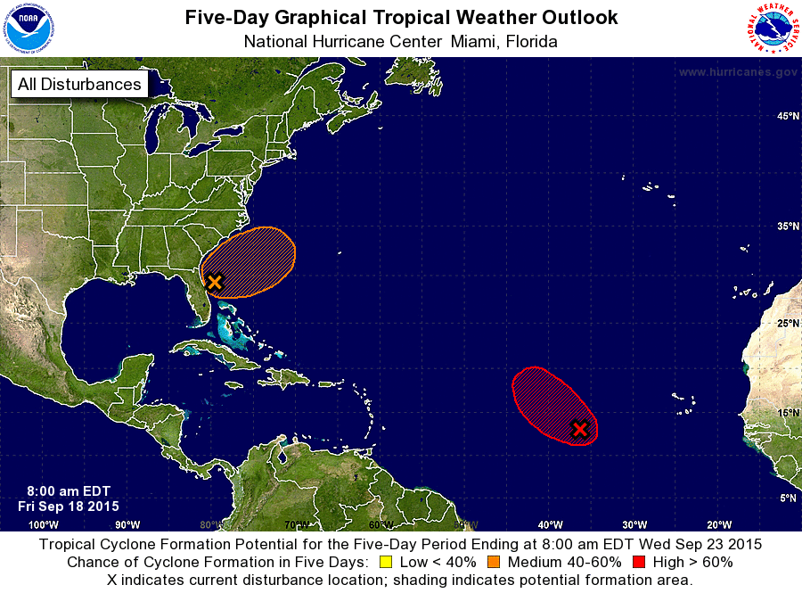
ZCZC MIATWOAT ALL
TTAA00 KNHC DDHHMM

TROPICAL WEATHER OUTLOOK
NWS NATIONAL HURRICANE CENTER MIAMI FL
800 AM EDT FRI SEP 18 2015

For the North Atlantic...Caribbean Sea and the Gulf of Mexico:

The National Hurricane Center is issuing advisories on Tropical
Depression Nine, located in the central tropical Atlantic.

1. A large area of disturbed weather extending from the eastern Gulf of
Mexico across the Florida peninsula and into the adjacent Atlantic
Ocean is associated with a broad surface trough interacting with an
upper-level trough. An area of low pressure has developed east of
the northern Florida peninsula overnight, and there is some
potential for this low to develop into a subtropical or tropical
cyclone during the next few days as it moves slowly northeastward
off the southeast coast of the United States. Regardless of
development, locally heavy rains are possible over portions of the
Florida Peninsula and coastal areas of Georgia and South Carolina
today. For more information on this system, see High Seas Forecasts
and products issued by your local National Weather Service office.
* Formation chance through 48 hours...low...20 percent
* Formation chance through 5 days...medium...40 percent

2. Shower activity associated with an area of low pressure located
about 800 miles west-southwest of the Cape Verde Islands continues
to show signs of organization. Conditions appear favorable for
development, and a tropical depression could form during the next
day or two while the system moves toward the west-northwest at 10 to
15 mph. After that time, conditions are expected to become less
conducive for tropical cyclone formation.
* Formation chance through 48 hours...high...80 percent
* Formation chance through 5 days...high...80 percent

High Seas Forecasts issued by the National Weather Service are
available under AWIPS header NFDHSFAT1, WMO header FZNT01 KWBC, and
on the Web at http://www.opc.ncep.noaa.gov/shtml/NFDHSFAT1.shtml.

Forecaster Brennan
List of Atlantic Outlooks (May 2023 - present)
List of East Pacific Outlooks (May 2023 - present)
List of Central Pacific Outlooks (May 2023 - present)
List of Atlantic Outlooks (July 2014 - April 2023)
List of East Pacific Outlooks (July 2014 - April 2023)
List of Central Pacific Outlooks (June 2019 - April 2023)
List of Atlantic Outlooks (June 2009 - June 2014)
List of East Pacific Outlooks (June 2009 - June 2014)