


NHC Graphical Outlook Archive
|
« Earliest Available ‹ Earlier Later › Latest Available » |
GIS Shapefiles |
| Eastern North Pacific | Atlantic |
|
Tropical Weather Outlook Text
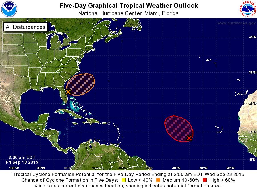
ZCZC MIATWOAT ALL
TTAA00 KNHC DDHHMM

TROPICAL WEATHER OUTLOOK
NWS NATIONAL HURRICANE CENTER MIAMI FL
200 AM EDT FRI SEP 18 2015

For the North Atlantic...Caribbean Sea and the Gulf of Mexico:

The National Hurricane Center is issuing advisories on Tropical
Depression Nine, located in the central tropical Atlantic.

1. Shower activity associated with the broad low pressure area located
about 750 miles west-southwest of the Cape Verde Islands has become
more concentrated during the past 24 hours.  Conditions appear
favorable for additional development, and a tropical depression
could form during the next day or two while the system moves toward
the west-northwest at 10 to 15 mph.  After that time, conditions are
expected to become less conducive for tropical cyclone formation.
* Formation chance through 48 hours...high...80 percent
* Formation chance through 5 days...high...80 percent

2. A large area of disturbed weather extending from the eastern Gulf of
Mexico across the Florida peninsula and into the adjacent Atlantic
Ocean is associated with a broad surface trough interacting with an
upper-level trough.  Surface observations indicate that a low
pressure area is forming just east of the northern Florida
Peninsula, and there is some potential for this low to develop into
a subtropical or tropical cyclone during the next few days as it
moves slowly northeastward. Regardless of development, locally heavy
rains are possible over portions of the Florida Peninsula today.
For more information on this system, see products from your local
National Weather Service office.
* Formation chance through 48 hours...low...20 percent
* Formation chance through 5 days...medium...40 percent

Forecaster Beven
List of Atlantic Outlooks (May 2023 - present)
List of East Pacific Outlooks (May 2023 - present)
List of Central Pacific Outlooks (May 2023 - present)
List of Atlantic Outlooks (July 2014 - April 2023)
List of East Pacific Outlooks (July 2014 - April 2023)
List of Central Pacific Outlooks (June 2019 - April 2023)
List of Atlantic Outlooks (June 2009 - June 2014)
List of East Pacific Outlooks (June 2009 - June 2014)