


NHC Graphical Outlook Archive
|
« Earliest Available ‹ Earlier Later › Latest Available » |
GIS Shapefiles |
| Eastern North Pacific | Atlantic |
|
Tropical Weather Outlook Text
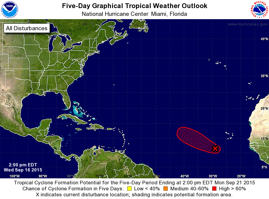
ZCZC MIATWOAT ALL
TTAA00 KNHC DDHHMM

TROPICAL WEATHER OUTLOOK
NWS NATIONAL HURRICANE CENTER MIAMI FL
200 PM EDT WED SEP 16 2015

For the North Atlantic...Caribbean Sea and the Gulf of Mexico:

The National Hurricane Center is issuing advisories on newly formed
Tropical Depression Nine, located in the central tropical Atlantic.

1. Shower activity has changed little in organization with a broad area
of low pressure located about 400 miles southwest of the Cape Verde
Islands. However, environmental conditions are expected to be
conducive for the formation of a tropical depression over the next
few days while this system moves west-northwestward at 10 to 15 mph.
* Formation chance through 48 hours...high...70 percent
* Formation chance through 5 days...high...80 percent

Public Advisories on Tropical Depression Nine are issued under WMO
header WTNT34 KNHC and under AWIPS header MIATCPAT4.
Forecast/Advisories on Tropical Depression Nine are issued under WMO
header WTNT24 KNHC and under AWIPS header MIATCMAT4.

Forecaster Brennan
List of Atlantic Outlooks (May 2023 - present)
List of East Pacific Outlooks (May 2023 - present)
List of Central Pacific Outlooks (May 2023 - present)
List of Atlantic Outlooks (July 2014 - April 2023)
List of East Pacific Outlooks (July 2014 - April 2023)
List of Central Pacific Outlooks (June 2019 - April 2023)
List of Atlantic Outlooks (June 2009 - June 2014)
List of East Pacific Outlooks (June 2009 - June 2014)