


NHC Graphical Outlook Archive
|
« Earliest Available ‹ Earlier Later › Latest Available » |
GIS Shapefiles |
| Eastern North Pacific | Atlantic |
|
Tropical Weather Outlook Text
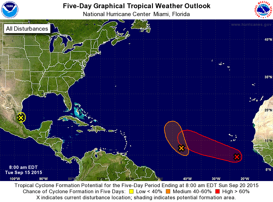
ZCZC MIATWOAT ALL
TTAA00 KNHC DDHHMM

TROPICAL WEATHER OUTLOOK
NWS NATIONAL HURRICANE CENTER MIAMI FL
800 AM EDT TUE SEP 15 2015

For the North Atlantic...Caribbean Sea and the Gulf of Mexico:

1. A low pressure area located about midway between the Cape Verde
Islands and the Lesser Antilles is producing disorganized showers
and thunderstorms. Some development of this low is still possible
during the next couple of days while it moves generally
northwestward. After that time, however, upper-level winds
are expected to become unfavorable for development.
* Formation chance through 48 hours...medium...60 percent
* Formation chance through 5 days...medium...60 percent

2. A low pressure system over the southwestern Gulf of Mexico has moved
inland near Tampico, Mexico. Although tropical cyclone development
is no longer expected due to land interaction, locally heavy
rainfall will be possible over portions of eastern Mexico during the
next couple of days as the system moves farther inland. These rains
could produce life-threatening flash floods and mudslides.
* Formation chance through 48 hours...low...near 0 percent
* Formation chance through 5 days...low...near 0 percent

3. A broad low pressure system is located about 375 miles south of the
southernmost Cape Verde Islands. Shower and thunderstorm activity
continues to show signs of organization, and environmental
conditions are expected to be conducive for the formation of a
tropical depression over the next few days while the system moves
west-northwestward at 10 to 15 mph.
* Formation chance through 48 hours...medium...50 percent
* Formation chance through 5 days...high...80 percent

Forecaster Stewart
List of Atlantic Outlooks (May 2023 - present)
List of East Pacific Outlooks (May 2023 - present)
List of Central Pacific Outlooks (May 2023 - present)
List of Atlantic Outlooks (July 2014 - April 2023)
List of East Pacific Outlooks (July 2014 - April 2023)
List of Central Pacific Outlooks (June 2019 - April 2023)
List of Atlantic Outlooks (June 2009 - June 2014)
List of East Pacific Outlooks (June 2009 - June 2014)