


NHC Graphical Outlook Archive
|
« Earliest Available ‹ Earlier Later › Latest Available » |
GIS Shapefiles |
| Eastern North Pacific | Atlantic |
|
Tropical Weather Outlook Text
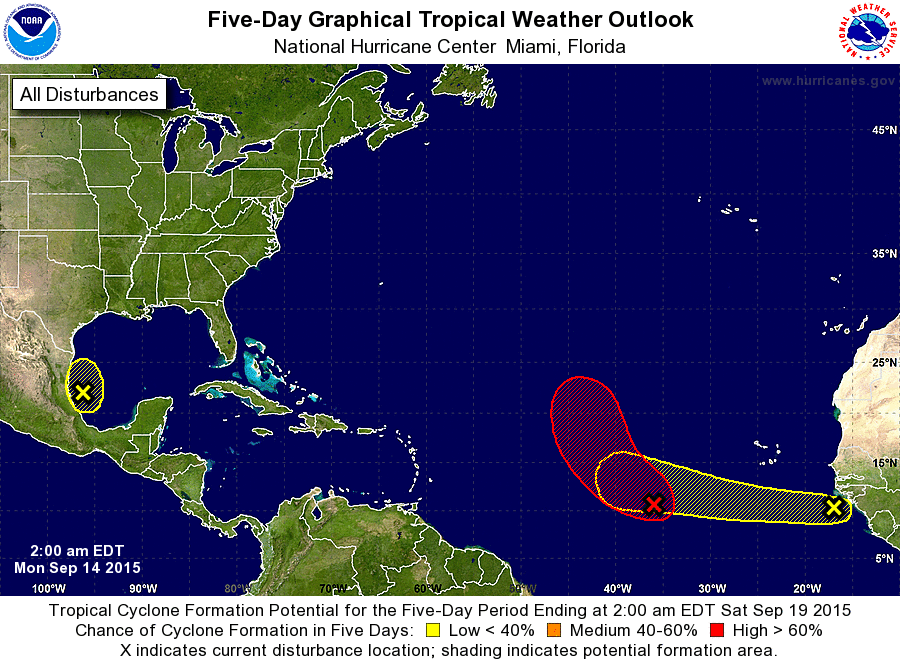
ZCZC MIATWOAT ALL
TTAA00 KNHC DDHHMM

TROPICAL WEATHER OUTLOOK
NWS NATIONAL HURRICANE CENTER MIAMI FL
200 AM EDT MON SEP 14 2015

For the North Atlantic...Caribbean Sea and the Gulf of Mexico:

1. Showers and thunderstorms associated with a broad low pressure
system located several hundred miles west-southwest of the Cape
Verde Islands continue to show signs of organization. Environmental
conditions are expected to be conducive for development, and this
system is likely to become a tropical depression during the next day
or two while it moves generally northwestward across the central
tropical Atlantic.
* Formation chance through 48 hours...high...80 percent
* Formation chance through 5 days...high...90 percent

2. Shower activity is minimal in association with an area of low
pressure located over the southwestern Gulf of Mexico. Some slow
development of this system is possible during the next couple of
days while it moves little.  After a couple of days, a slow
west-northwestward motion toward Mexico is expected and land
interaction should limit development.  An Air Force Reserve
reconnaissance aircraft is scheduled to investigate the system
Monday afternoon, if necessary.
* Formation chance through 48 hours...low...20 percent
* Formation chance through 5 days...low...30 percent

3. A tropical wave located just off the west coast of Africa is
producing disorganized showers and thunderstorms. Environmental
conditions are expected to be conducive for gradual development of
this wave during the next several days while it moves westward
at 10 to 15 mph.
* Formation chance through 48 hours...low...near 0 percent
* Formation chance through 5 days...low...30 percent

Forecaster Cangialosi
List of Atlantic Outlooks (May 2023 - present)
List of East Pacific Outlooks (May 2023 - present)
List of Central Pacific Outlooks (May 2023 - present)
List of Atlantic Outlooks (July 2014 - April 2023)
List of East Pacific Outlooks (July 2014 - April 2023)
List of Central Pacific Outlooks (June 2019 - April 2023)
List of Atlantic Outlooks (June 2009 - June 2014)
List of East Pacific Outlooks (June 2009 - June 2014)