


NHC Graphical Outlook Archive
|
« Earliest Available ‹ Earlier Later › Latest Available » |
GIS Shapefiles |
| Eastern North Pacific | Atlantic |
|
Tropical Weather Outlook Text
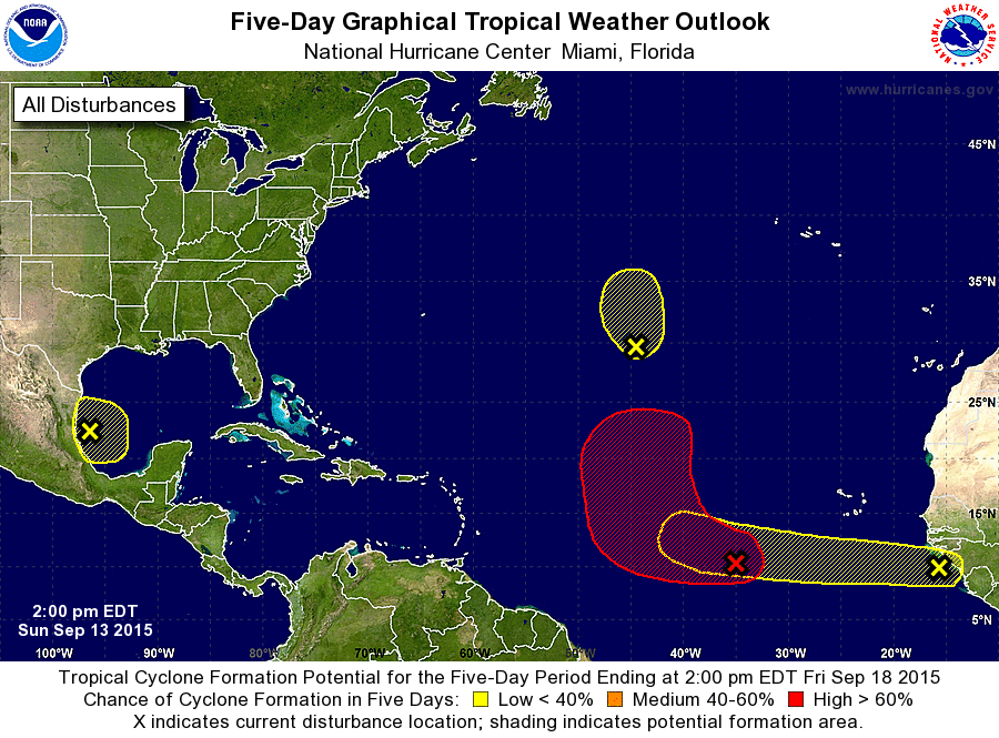
ZCZC MIATWOAT ALL
TTAA00 KNHC DDHHMM

TROPICAL WEATHER OUTLOOK
NWS NATIONAL HURRICANE CENTER MIAMI FL
200 PM EDT SUN SEP 13 2015

For the North Atlantic...Caribbean Sea and the Gulf of Mexico:

1. An area of disturbed weather associated with a broad low pressure
system located several hundred miles southwest of the Cape Verde
Islands is showing signs of organization. Environmental conditions
are conducive for development, and a tropical depression could form
during the next day or two while the system moves west-northwestward
to northwestward across the central tropical Atlantic.
* Formation chance through 48 hours...high...70 percent
* Formation chance through 5 days...high...90 percent

2. An area of disturbed weather has developed in association with a
weak low pressure system located over the southwestern Gulf of
Mexico. Upper-level winds are expected to be only marginally
conducive for development over the next few days before becoming
unfavorable by late Wednesday. Little movement is expected during
the next couple of days, followed by a slow motion toward the west
or west-northwest on Wednesday. An Air Force Reserve reconnaissance
aircraft is scheduled to investigate the system Monday afternoon,
if necessary.
* Formation chance through 48 hours...low...10 percent
* Formation chance through 5 days...low...20 percent

3. A tropical wave has emerged off the west coast of Africa several
hundred miles southeast of the Cape Verde Islands. Environmental
conditions are expected to be conducive for gradual development of
this disturbance over the next several days while it moves westward
at 10 to 15 mph.
* Formation chance through 48 hours...low...near 0 percent
* Formation chance through 5 days...low...20 percent

4. A small low pressure system located about 975 miles southwest of
the Azores is producing minimal shower activity. Environmental
conditions are becoming unfavorable for development, and tropical
cyclone formation is not expected while the system moves
northwestward at 10 to 15 mph over the next couple of days.
* Formation chance through 48 hours...low...near 0 percent
* Formation chance through 5 days...low...near 0 percent

Forecaster Stewart
List of Atlantic Outlooks (May 2023 - present)
List of East Pacific Outlooks (May 2023 - present)
List of Central Pacific Outlooks (May 2023 - present)
List of Atlantic Outlooks (July 2014 - April 2023)
List of East Pacific Outlooks (July 2014 - April 2023)
List of Central Pacific Outlooks (June 2019 - April 2023)
List of Atlantic Outlooks (June 2009 - June 2014)
List of East Pacific Outlooks (June 2009 - June 2014)