


NHC Graphical Outlook Archive
|
« Earliest Available ‹ Earlier Later › Latest Available » |
GIS Shapefiles |
| Eastern North Pacific | Atlantic |
|
Tropical Weather Outlook Text
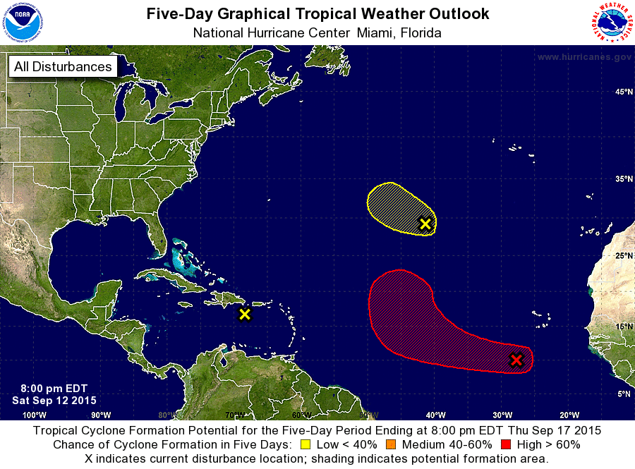
ZCZC MIATWOAT ALL
TTAA00 KNHC DDHHMM

TROPICAL WEATHER OUTLOOK
NWS NATIONAL HURRICANE CENTER MIAMI FL
800 PM EDT SAT SEP 12 2015

For the North Atlantic...Caribbean Sea and the Gulf of Mexico:

1. Minimal shower and thunderstorm activity is currently associated
with the remnants of Tropical Storm Grace over the northeastern
Caribbean Sea.  Upper-level winds are not expected to be favorable
for redevelopment of this system during the next several days.
However, isolated heavy rain and gusty winds are still possible
across portions of the Virgin Islands, Puerto Rico, Hispaniola,
Cuba, and the Bahamas during the next day or two while the system
moves west-northwestward at 15 to 20 mph.
* Formation chance through 48 hours...low...near 0 percent
* Formation chance through 5 days...low...near 0 percent

2. Shower activity has increased over the past 24 hours in association
with a tropical wave located several hundred miles southwest of the
Cape Verde Islands.  Environmental conditions are forecast to be
favorable for development, and a tropical depression could form
during the next several days while the system moves west-
northwestward to northwestward across the central tropical Atlantic.
* Formation chance through 48 hours...low...30 percent
* Formation chance through 5 days...high...70 percent

3. A small low pressure system located about 950 miles southwest of
the Azores is producing minimal shower and thunderstorm activity.
Development, if any, of this low is expected to be slow to occur
while it moves westward to west-northwestward at about 10 mph over
the next couple of days.
* Formation chance through 48 hours...low...10 percent
* Formation chance through 5 days...low...10 percent

Forecaster Beven
List of Atlantic Outlooks (May 2023 - present)
List of East Pacific Outlooks (May 2023 - present)
List of Central Pacific Outlooks (May 2023 - present)
List of Atlantic Outlooks (July 2014 - April 2023)
List of East Pacific Outlooks (July 2014 - April 2023)
List of Central Pacific Outlooks (June 2019 - April 2023)
List of Atlantic Outlooks (June 2009 - June 2014)
List of East Pacific Outlooks (June 2009 - June 2014)