


NHC Graphical Outlook Archive
|
« Earliest Available ‹ Earlier Later › Latest Available » |
GIS Shapefiles |
| Eastern North Pacific | Atlantic |
|
Tropical Weather Outlook Text
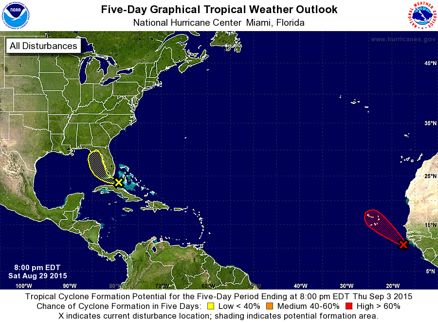
ZCZC MIATWOAT ALL
TTAA00 KNHC DDHHMM

TROPICAL WEATHER OUTLOOK
NWS NATIONAL HURRICANE CENTER MIAMI FL
800 PM EDT SAT AUG 29 2015

For the North Atlantic...Caribbean Sea and the Gulf of Mexico:

1. A trough of low pressure associated with the remnants of Erika is
moving quickly west-northwestward across the Florida Straits this
evening. There are no signs of redevelopment at this time, and
upper-level winds should remain unfavorable for tropical cyclone
formation. Regardless of this system's prospects for regeneration,
locally heavy rains and gusty winds are expected to spread across
portions of the western Bahamas, south Florida and the Keys tonight
and Sunday. This activity should spread northwestward and then
northward across the eastern Gulf of Mexico later Sunday and Monday.
Additional information on this system can be found in marine
forecasts and local forecast products issued by the National Weather
Service and the meteorological services of Cuba and the Bahamas.
* Formation chance through 48 hours...low...20 percent
* Formation chance through 5 days...low...30 percent

2. Satellite pictures indicate that thunderstorm activity associated
with a low pressure area that recently moved off of the west coast
of Africa is becoming better organized, and a tropical depression
could be forming. If this development trend continues, advisories
would likely be initiated tonight or Sunday.  This system is
expected to move northwest toward the Cape Verde Islands at 10 to
15 mph, and interests in those islands should closely monitor the
progress of this disturbance.
* Formation chance through 48 hours...high...80 percent
* Formation chance through 5 days...high...90 percent

Forecaster Kimberlain
List of Atlantic Outlooks (May 2023 - present)
List of East Pacific Outlooks (May 2023 - present)
List of Central Pacific Outlooks (May 2023 - present)
List of Atlantic Outlooks (July 2014 - April 2023)
List of East Pacific Outlooks (July 2014 - April 2023)
List of Central Pacific Outlooks (June 2019 - April 2023)
List of Atlantic Outlooks (June 2009 - June 2014)
List of East Pacific Outlooks (June 2009 - June 2014)