


NHC Graphical Outlook Archive
|
« Earliest Available ‹ Earlier Later › Latest Available » |
GIS Shapefiles |
| Eastern North Pacific | Atlantic |
|
Tropical Weather Outlook Text
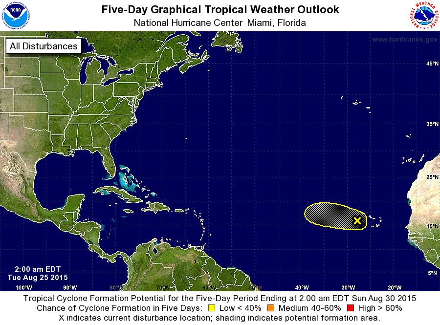
ZCZC MIATWOAT ALL
TTAA00 KNHC DDHHMM

TROPICAL WEATHER OUTLOOK
NWS NATIONAL HURRICANE CENTER MIAMI FL
200 AM EDT TUE AUG 25 2015

For the North Atlantic...Caribbean Sea and the Gulf of Mexico:

The National Hurricane Center is issuing advisories on newly formed
Tropical Storm Erika, located several hundred miles east of the
Leeward Islands.

1. A tropical wave and associated low pressure area located just west
of the Cape Verde Islands is producing disorganized showers and
thunderstorms. Environmental conditions are not expected to be
conducive for significant development of this system while it moves
westward at 15 to 20 mph over the next few days.
* Formation chance through 48 hours...low...10 percent
* Formation chance through 5 days...low...10 percent

Public Advisories on Erika are issued under WMO header WTNT35 KNHC
and under AWIPS header MIATCPAT5. Forecast/Advisories on Erika are
issued under WMO header WTNT25 KNHC and under AWIPS header
MIATCMAT5.

Forecaster Brennan
List of Atlantic Outlooks (May 2023 - present)
List of East Pacific Outlooks (May 2023 - present)
List of Central Pacific Outlooks (May 2023 - present)
List of Atlantic Outlooks (July 2014 - April 2023)
List of East Pacific Outlooks (July 2014 - April 2023)
List of Central Pacific Outlooks (June 2019 - April 2023)
List of Atlantic Outlooks (June 2009 - June 2014)
List of East Pacific Outlooks (June 2009 - June 2014)