


NHC Graphical Outlook Archive
|
« Earliest Available ‹ Earlier Later › Latest Available » |
GIS Shapefiles |
| Eastern North Pacific | Atlantic |
|
Tropical Weather Outlook Text
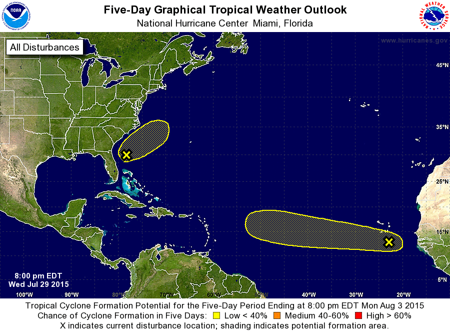
ZCZC MIATWOAT ALL
TTAA00 KNHC DDHHMM

TROPICAL WEATHER OUTLOOK
NWS NATIONAL HURRICANE CENTER MIAMI FL
800 PM EDT WED JUL 29 2015

For the North Atlantic...Caribbean Sea and the Gulf of Mexico:

1. A tropical wave accompanied by a broad area of low pressure
continues to produce showers and thunderstorms a couple of hundred
miles south of the Cape Verde Islands.  Some slow development of
this system is possible while it moves westward near 15 mph during
the next several days.
* Formation chance through 48 hours...low...10 percent
* Formation chance through 5 days...low...30 percent

2. Satellite imagery and surface observations indicate that a low
pressure area, accompanied by disorganized thunderstorm activity,
has formed a couple of hundred miles east of the coast of northern
Florida.  Additional development during the next couple of days, if
any, should be slow to occur due to strong upper-level winds.  The
low is expected to move slowly northeastward during that time and
merge with a frontal system by the weekend.
* Formation chance through 48 hours...low...10 percent
* Formation chance through 5 days...low...10 percent

Forecaster Beven
List of Atlantic Outlooks (May 2023 - present)
List of East Pacific Outlooks (May 2023 - present)
List of Central Pacific Outlooks (May 2023 - present)
List of Atlantic Outlooks (July 2014 - April 2023)
List of East Pacific Outlooks (July 2014 - April 2023)
List of Central Pacific Outlooks (June 2019 - April 2023)
List of Atlantic Outlooks (June 2009 - June 2014)
List of East Pacific Outlooks (June 2009 - June 2014)