


NHC Graphical Outlook Archive
|
« Earliest Available ‹ Earlier Later › Latest Available » |
GIS Shapefiles |
| Eastern Pacific | Atlantic |
|
Tropical Weather Outlook Text
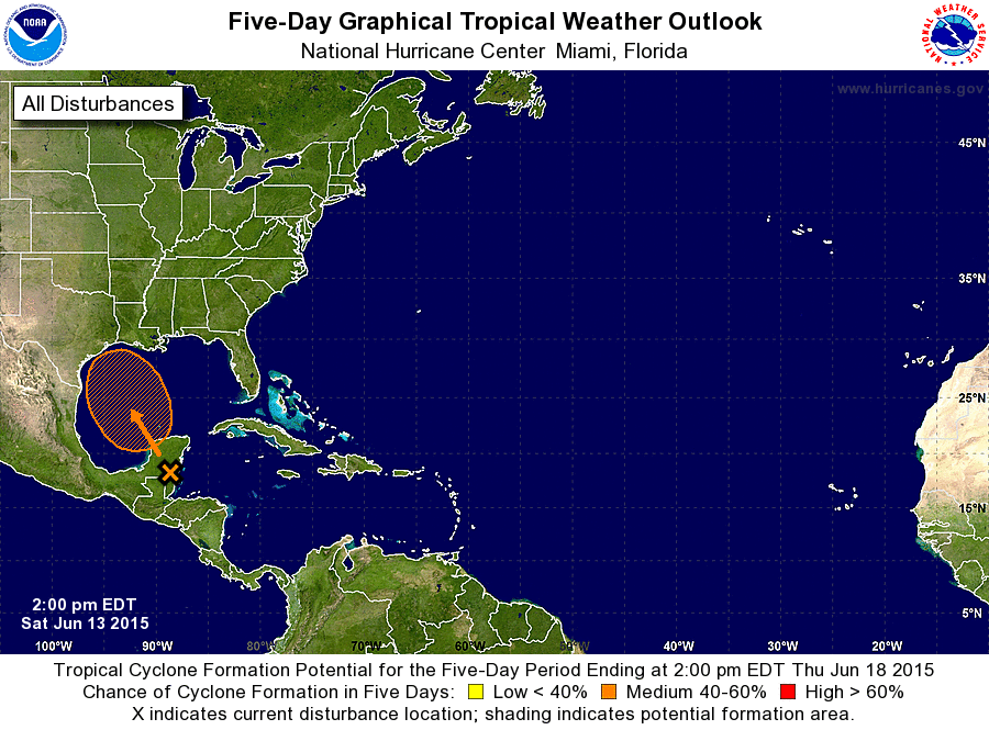
ZCZC MIATWOAT ALL
TTAA00 KNHC DDHHMM

TROPICAL WEATHER OUTLOOK
NWS NATIONAL HURRICANE CENTER MIAMI FL
200 PM EDT SAT JUN 13 2015

For the North Atlantic...Caribbean Sea and the Gulf of Mexico:

1. A broad area of low pressure over northern Belize and the Yucatan
peninsula is producing a large area of showers and thunderstorms and
winds to near gale force over the northwestern Caribbean Sea.
Environmental conditions should support some development of this
system when it moves over the southwestern Gulf of Mexico by
tomorrow night and across the northwestern Gulf of Mexico through
Tuesday. Regardless of development, heavy rains are possible over
the Yucatan peninsula during the next day or so.  Additional
information on this system can be found in High Seas Forecasts
issued by the National Weather Service.
* Formation chance through 48 hours...medium...40 percent
* Formation chance through 5 days...medium...50 percent

High Seas Forecasts can be found under AWIPS header NFDHSFAT1 and
WMO header FZNT01 KWBC.

Forecaster Cangialosi/Blake
List of Atlantic Outlooks (May 2023 - present)
List of East Pacific Outlooks (May 2023 - present)
List of Central Pacific Outlooks (May 2023 - present)
List of Atlantic Outlooks (July 2014 - April 2023)
List of East Pacific Outlooks (July 2014 - April 2023)
List of Central Pacific Outlooks (June 2019 - April 2023)
List of Atlantic Outlooks (June 2009 - June 2014)
List of East Pacific Outlooks (June 2009 - June 2014)