


NHC Graphical Outlook Archive
|
« Earliest Available ‹ Earlier Later › Latest Available » |
| Eastern Pacific | Atlantic |
|
|
(mouse over shaded areas for details; click on shaded areas or disturbance numbers to switch views) |
Tropical Weather Outlook Text
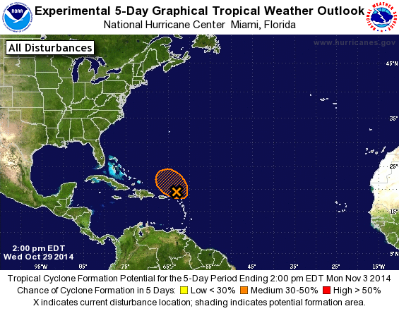
TROPICAL WEATHER OUTLOOK...CORRECTED
NWS NATIONAL HURRICANE CENTER MIAMI FL
200 PM EDT WED OCT 29 2014

Corrected second sentence

For the North Atlantic...Caribbean Sea and the Gulf of Mexico:

1. An area of low pressure has formed just north of the Leeward
Islands and is producing a large area of disorganized showers and
thunderstorms. Although upper-level winds are not particularly
conducive, some development of this disturbance is possible during
the next day or so while it moves west-northwestward to
northwestward at 10 to 15 mph.  After that time, conditions are
forecast to become unfavorable for tropical cyclone formation
while the system turns northward.
* Formation chance through 48 hours...medium...30 percent.
* Formation chance through 5 days...medium...30 percent.

Forecaster Blake/Brown
List of Atlantic Outlooks (May 2023 - present)
List of East Pacific Outlooks (May 2023 - present)
List of Central Pacific Outlooks (May 2023 - present)
List of Atlantic Outlooks (July 2014 - April 2023)
List of East Pacific Outlooks (July 2014 - April 2023)
List of Central Pacific Outlooks (June 2019 - April 2023)
List of Atlantic Outlooks (June 2009 - June 2014)
List of East Pacific Outlooks (June 2009 - June 2014)